| home | alignments |
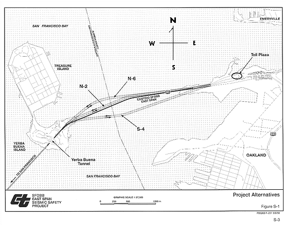
"Alignment" refers to the path the bridge is planned to take across the east bay. It is compared to the path of the current bridge, where all paths to the north are called "northern alignments," and all paths to the south "southern alignments." Proposed alignments to the north are prefixed "N" and to the south "S." The only alignment that allows for a straight bridge from Yerba Buena Island to Oakland is the southern alignment designated S-1 (a straight line from YBI to Oakland just south of the existing bridge).
| home | alignments |
The proposed new span would run to the north of the present bridge along a path called the "northern alignment." Several possible alignments, including a few different northern alignments, were publicly mentioned and shown in official documents. Only one of them (N-6) was recommended by the Engineering and Design Advisory Panel (EDAP) and subsequently approved by the Metropolitan Transportation Commission. The proposed N-6 alignment extends from Yerba Buena tunnel in a northeasterly direction, then abruptly changes direction to head back toward Oakland on a southeasterly course.
Dr. Abolhassan Astaneh of U.C. Berkeley pointed out in 1997 that an underwater canyon, which was a river bed during the last ice age, was located directly under this "preferred" alignment. This fact was published in 1930s geological surveys, but was overlooked as MTC rushed to approve the proposed design and the alignment that is used to justify it. A bridge built over the canyon would be vulnerable to underwater mudslides, with risk of damage or even total collapse, particularly in an earthquake. Confirmation of this by California's Department of Transportation (Caltrans) led to a rejection of EDAP's preferred far northern alignment. A compromise brought the alignment about 1000 feet further south, but still well north of the present bridge. The less extreme northern alignment necessitated shortening the proposed suspension segment called the "signature bridge." This purely decorative bridge thus shrank from going about 20% of the way across the bay, to only 15%. But this meant its central tower would be right in the middle of a little-used shipping lane which the suspension structure was supposed to have spanned. The single tower that supports the whole suspension structure was then planned to be closer to Yerba Buena Island in the middle of the bay (on the left side of the map above), and became radically asymmetrical. Its longer section would freely swing out over the bay, and because it is "self-anchored" no cables will attach it to the ground. The asymmetrical, self anchored design is unlike any suspension bridge in the world, and will cause it to be unbalanced. This design has serious seismic deficiencies, and raises grave ethical concerns.
A "southern alignment", one south of the existing bridge, is preferred by the City of San Francisco and the US Navy. Caltrans has also supported a straight, southern alignment, though EDAP, in recommending its own crooked northerly bridge proposals, effectively eliminated a southern alignment from contention in the MTC process. A southern alignment would best avoid interfering with both the Navy's historical site on Yerba Buena Island and San Francisco's planned development of Treasure Island. The Metropolitan Transportation Commission (MTC) Bay Bridge Task Force Chair has ridiculed these considerations as trivial compared to seismic safety concerns. (She says the replacement bridge needs to be expedited.) However, federal law mandates consideration of development plans and historic sites in major bridge projects. Early consideration is meant to ensure that a major project does not create controversy and conflict. Rational planning which takes into consideration political, social, transportation and environmental needs is supposed to avoid delay and in this case most likely would have done so. In this project the most important considerations have been for Caltrans to award contracts for designing a unbuildable bridge to T.Y. Lin International and affiliated companies, paying URS/Woodward-Clyde to write sub-mediocre environmental studies, and denying responsibility for the resulting political controversy, planning chaos, and delays which put the public at risk.
A study by a private engineering firm commissioned by the City of San Francisco considered the southern alignment, designated S-1, as feasible and preferable. The Caltrans project manager has stated his preference for this alignment. The S-1 alignment, the only straight route, would be the shortest distance between two points. It would consequently be the most economical, even with the preposterous allowance of $100 million for moving a sewer pipe. The S-1 would drastically diminish political opposition, and make way for designs to accommodate rail, bicycle and other transit options. A straight bridge would also avoid (1) the structural difficulties associated with curved bridges; (2) the inordinately complex task of predicting the seismic behavior of twin parallel curved structures; and (3) the unnecessarily dangerous task of appending a steel self-anchored suspension structure, inherently unstable in concept, to a concrete viaduct which has a radically different response in earthquakes.
.