(excerpts from summary and first two sections)
This document may be found, in its entirety at:
http://www.dot.ca.gov/
FHWA-CA-EIS-98-01-D
04-SF-80 KP 12.2/KP 14.3
04-ALA-80 KP 0.0/KP 2.1
EA# 04-251-012000
SAN FRANCISCO - OAKLAND BAY BRIDGE
EAST SPAN SEISMIC SAFETY PROJECT
on Interstate 80 between
Yerba Buena Island and Oakland
in San Francisco and Alameda Counties
DRAFT ENVIRONMENTAL IMPACT STATEMENT/
Submitted pursuant to 42 USC 4332 (2)(c) and 49 USC 303
by the
US DEPARTMENT OF TRANSPORTATION FEDERAL HIGHWAY ADMINISTRATION
and
THE STATE OF CALIFORNIA DEPARTMENT OF TRANSPORTATION
In Cooperation with the
UNITED STATES COAST GUARD
HARRY YAHATA S/9/21/98
District Director
District 4
California Department of Transportation
JEFFREY A. LINDLEY S/9/21/98
Division Administrator
Federal Highway Administration
The following persons may be contacted for additional information concerning this document:
Brian Maroney, Project Manager
East Span Seismic Safety Project
Toll Bridge Program
Caltrans District 4
111 Grand Avenue
P.O. Box 23660
Oakland, CA 94623-0660
(510) 286-5885
John R. Schultz, Chief
District Operations North
Federal Highway Administration
980 Ninth Street, Suite 400
Sacramento, CA 95814-2724
(916) 498-5041
ABSTRACT: Caltrans proposes to ensure a lifeline vehicular connection between Yerba Buena Island in San Francisco and the SFOBB Toll Plaza in Oakland by seismic upgrading of the existing East Span. Alternatives include existing structure retrofit, two replacement alternatives north of the existing bridge, and one replacement alternative to the south. Three bridge main span design variations (cable stayed, self-anchored suspension, and skyway) are being considered. Long-term and temporary impacts include: potential displacement of Caltrans and USCG buildings; change in visual setting; noise; hazardous wastes; water quality; displacement of waters of the U.S. and special aquatic sites; disturbance of special status species habitat; and displacement of archaeological and historic resources. Proposed mitigation measures include: revegetation; consideration of soundwalls; removal of contaminated soils; in-kind replacement of special aquatic sites; treatment plans for archaeological resources; documentation of historic structures; and construction period traffic control measures and Best Management Practices.
Comments on this Draft ElS are due by November 9, 1998, and should be sent to: Mara Melandry, Caltrans District 4, 111 Grand Avenue (P.O. Box 23660), Oakland, California 94623-0660, (510) 286-5582 or by sending e-mail to sfobb.dist04@dot.ca.gov.
To Table of Contents
[end DEIS 00]
![]()
PREFACE
This Draft Environmental Impact Statement (EIS) has been prepared pursuant to the requirements of the National Environmental Policy Act (NEPA) by the Federal Highway Administration (FHWA) and the California Department of Transportation (Caltrans), acting as joint lead agencies. The U.S. Coast Guard is a cooperating agency. It evaluates potential impacts of seismic retrofit and replacement alternatives proposed by Caltrans for improving the San Francisco-Oakland Bay Bridge (SFOBB) East Span in order to provide a seismically upgraded bridge over a portion of San Francisco Bay between Yerba Buena Island (YBI) in San Francisco and Oakland. This project is exempt by statute from the requirements of the California Environmental Quality Act (CEQA).
This project is one of several that Caltrans is undertaking to address the overall need to provide a lifeline bridge connection between the cities of San Francisco and Oakland. The other projects include replacing the West Approach in San Francisco, retrofitting the West Span, West YBI Viaduct, and YBI Tunnel, and the interim retrofit on the East Span.
This document is being circulated for a 45-day public review period, during which public hearings will be held on the project. Public and agency comments will be accepted orally and in writing at the public hearings and in writing until the close of the public review period on November 9, 1998. Following receipt and consideration of all public and agency comments on the Draft EIS, Caltrans and FHWA will identify a preferred alternative and a Final EIS will be prepared. The Final EIS will identify the preferred alternative, impacts and mitigation commitments, and will provide a written response to all comments received during the public comment period.
This Draft EIS describes the project purpose and need (Chapter 1), alternatives under consideration and alternatives considered and withdrawn (Chapter 2), affected environment (Chapter 3), project impacts by alternative, and proposed mitigation measures (Chapter 4). Chapter 5 explains the project’s exemption from the requirements of CEQA. Chapter 6 provides the Draft Section 4(f) Evaluation. Chapter 7 is an index of key words.
Appendices to this Draft EIS include figures and drawings referenced in the text (Appendix A); qualifications of preparers (Appendix B); a list of recipients of this document (Appendix C); and a glossary of terms and acronyms (Appendix D). Appendices E-G include documentation of consultation and correspondence. The CEQA Statutory Exemption form is in Appendix H. Appendix I is an explanation of relocation assistance provided to residents or businesses displaced by the project; a bibliography is in Appendix J. A description of rock motion anticipated in a seismic event is in Appendix K.
The impacts information presented herein is based upon the following technical studies that have been prepared for the project.
Air Quality Memorandum
Bicycle and Pedestrian Study
Biological Assessment
Community Impact Assessment
Extended Study Report, Archaeological
Resources
Finding of Adverse Effect: Built
Environment
Finding of Effect for Archaelogical
Resources
Hazardous Wastes Assessment
Historic Property Survey Report
Location Hydraulic Study
Natural Environment Study
Noise and Vibration Study
Draft Relocation Impact Report
Traffic Circulation, Access, and Parking
Assessment
Visual Impact Assessment
Alternatives addressed in this Draft EIS include replacement bridge alternatives defined through an extensive community involvement process led by the Metropolitan Transportation Commission (MTC). The MTC is a regional governmental agency that provides regional transportation planning and coordination of transportation activities for the nine-county Bay Area. The MTC functions as both the regional transportation planning agency (RTPA), a state designation, and for federal purposes under 23 CFR 134, as the region’s metropolitan planning organization (MPO). As such, the MTC is responsible for implementing the Regional Transportation Plan (RTP), which is a comprehensive blueprint for the development of mass transit, highway, airport, seaport, railroad, and bicycle and pedestrian facilities. Requests from local agencies for state and federal grants for transportation projects are screened by the MTC to determine their compatibility with the RTP. The MTC is also the Bay Area Toll Authority, under Section 30950 of the California Streets and Highway Code.
The MTC organized the San Francisco-Oakland Bay Bridge Design Task Force (Task Force) to consider replacement bridge alternatives following Governor Pete Wilson’s February 1997 decision that replacement alternatives should be considered. All the members of the Task Force are MTC Commissioners. The Task Force mandate was to develop a consensus recommendation on a design option for a new eastern span of the SFOBB and recommend any additional features that might be included in the design of the bridge that would not be borne by funding allocated from the State of California. The additional features would be paid by Bay Area bridge users through a toll surcharge at the state-owned toll bridges.
The MTC Task Force formed an Engineering and Design Advisory Panel (EDAP) to advise the Task Force on issues of cost, engineering feasibility, design factors, and seismic safety. The EDAP is comprised of technical experts in structural and civil engineering and architecture. EDAP deliberations included meetings and workshops open to the public for presentation of design concepts from interested parties. Beginning with the first of four formal public hearings on March 27, 1997, the Task Force has considered replacement bridge options (e.g., different types of replacement bridge structures) and the cost and feasibility of including design features such as "signature" bridge structures and a pedestrian/bicycle path.
The Task Force made its summary recommendations to Caltrans on July 30, 1997, concerning replacement bridge types, alignment, and a request for additional analysis needed to determine cost and feasibility of design components and features. Recommendations of the Task Force were transmitted to Caltrans and the State Legislature to assist in the determination of potential funding needs for the project.
In response to Task Force recommendations, Caltrans initiated the requested preliminary design studies. The 30 percent design studies were used to determine the seismic performance, cost, and aesthetics of the bridge types recommended for further study by the Task Force. The EDAP reviewed results of design studies in a series of public meetings and made specific recommendations to the Task Force (see Appendix E: Consultation and Coordination). On June 24, 1998, following extensive public comment, the Task Force forwarded an advisory recommendation to MTC that the replacement structure be a concrete skyway structure with an asymmetrical self-anchored suspension main span supported by a single steel tower. A 4.7-meter (15.5-foot) wide pedestrian/bicycle path 0.3 meter (one foot) higher than the traffic lanes located on the south side of the eastbound structure was also recommended and accepted by the MTC.
Alternative N-6, self-anchored suspension design variation, analyzed in this Draft EIS matches the bridge type recommendation defined through the Task Force proceedings. Although this alternative represents the bridge type recommendation of the MTC Task Force, it is not designated as a Recommended or Preferred Alternative in the Draft EIS. The Task Force recommendation is considered advisory and represents the locally preferred option. Caltrans and the FHWA have considered and performed preliminary engineering on a range of possible project alternatives in accordance with NEPA requirements and in consultation with permitting and regulatory agencies. Five alternatives (No-Build, Retrofit Existing Structure, two northern alignments, and one southern alignment) are currently under consideration for the East Span Project. Caltrans and the FHWA will identify a preferred alternative following circulation of this Draft EIS and consideration of public and agency comments on the document.
Copies of the Draft EIS and technical studies are available for public review at the following locations:
Caltrans Public Information Office
111 Grand Avenue
Oakland, CA 94612-3006
(510) 286-4444
Contra Costa County Library
1750 Oakpark Boulevard
Pleasant Hill, CA 94526
(925) 646-6434
Metropolitan Transportation Commission/Association of Bay Area Governments Library
101 Eighth Street
Oakland, CA 94607
(510) 464-7700
Oakland Main Library
125 14th Street
Oakland, CA 94612
(510) 238-3134
San Francisco Main Library
100 Larkin Street
San Francisco, CA 94102
(415) 557-4400
John F. Kennedy Library
505 Santa Clara Street
Vallejo, CA 94590
(707) 553-5568
Caltrans can be contacted by e-mail at sfobb.dist04@dot.ca.gov.
Click here to return to the Table of Contents
[end DEIS 01]
![]()
SUMMARY
The California Department of Transportation (Caltrans) proposes to retrofit or replace the San Francisco-Oakland Bay Bridge (SFOBB) East Span, which has carried vehicles between Yerba Buena Island (YBI) and Oakland since 1936. The East Span is a double-deck structure 3,696 meters (12,127 feet) in length carrying five traffic lanes in each direction, east- and westbound.
This Draft Environmental Impact Statement (EIS) has been prepared by Caltrans and the Federal Highway Administration (FHWA) pursuant to the National Environmental Policy Act (NEPA) to analyze potential environmental and socioeconomic impacts of several possible replacement bridge alternatives, as well as retrofit of the existing structure and no-build alternatives. The project is exempt by statute from the provisions of the California Environmental Quality Act (CEQA). The U.S. Coast Guard (USCG) is a cooperating agency.
S.1 PROJECT VICINITY AND PROJECT LIMITS
Alternatives analyzed in this Draft EIS would seismically retrofit or replace the East Span, involving construction activities and physical changes on both ends of the span and within the Bay. The west end of the project area is located west of the tunnel on YBI within the City and County of San Francisco (CCSF), and the east end of the project area is located in the City of Oakland, Alameda County. The project study area includes San Francisco Bay waters adjacent to the bridge in which construction activities might occur. In addition, Bay waters on the north side of YBI are included within the project area to allow staging for large construction equipment and bulk materials to be delivered to YBI by barge or vessel.
S.2 PURPOSE OF AND NEED FOR THE PROJECT
The SFOBB is an important part of the Bay Area as it provides regional access between the San Francisco Peninsula and the East Bay. Approximately 350,000 people in 274,000 vehicles currently use the bridge each day. As a component of Interstate 80 (I-80), it is also a critical link in the interstate network.
The purpose of the East Span Project is to provide a seismically upgraded vehicular crossing for current and future users between YBI and Oakland. This project is one of several that Caltrans is undertaking to address the overall need to provide a lifeline bridge connection on SFOBB between the cities of San Francisco and Oakland. The other projects include replacing the west approach in San Francisco, retrofitting the West Span, West YBI Viaduct, and YBI tunnel, and the interim retrofit on the East Span.
The existing East Span must be replaced or retrofitted because: it is not expected to withstand a maximum credible earthquake (MCE) on the San Andreas fault (an earthquake of magnitude 8 on the Richter scale) or Hayward fault (an earthquake of magnitude 7 1/4); it does not meet "lifeline" criteria for providing emergency relief access following an MCE; and, it does not meet current operations and safety design standards.
The Retrofit Existing Structure Alternative and the replacement alternatives would meet the project purpose and need to varying degrees. All replacement alternatives would fulfill the project purpose and address the need to provide a lifeline connection between the East Bay and Yerba Buena and Treasure Islands, to enable the East Span to withstand an MCE, and to satisfy current operational and safety standards. The Retrofit Existing Structure Alternative would retrofit the existing bridge to withstand an MCE, but the bridge would most likely experience substantial damage. The Retrofit Existing Structure Alternative would not permit changes to the existing bridge; therefore, current design standards could not be attained. The No-Build Alternative does not satisfy the project purpose and need.
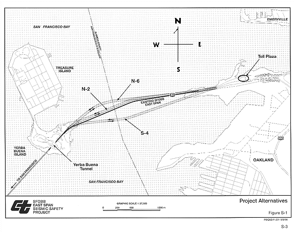
Twelve alternatives, in addition to the No-Build Alternative, were considered during the scoping phase of this project. Four alternatives plus the No-Build Alternative were carried forward for the detailed analysis in this EIS, as described below. The project alternatives are shown on Figure S-1.
The No-Build Alternative would retain the existing SFOBB East Span. The No-Build Alternative assumes that the interim retrofitting of the East Span has been completed as a prior project. The Interim Retrofit Project is currently under way to strengthen bents and columns on the viaduct section on YBI and strengthen piers, bents, and trusses at selected locations on the structure, so that the existing East Span would be able to withstand a moderate earthquake. This work is expected to be completed by late 1998. The No-Build Alternative is evaluated primarily as a basis for comparison with the build alternatives.
S.3.2 Retrofit Existing Structure Alternative
The Retrofit Existing Structure Alternative would seismically retrofit and rehabilitate the existing East Span to withstand an MCE. The alignment of the bridge would remain unchanged. Improvements would be made to the existing structure and the East YBI Viaduct. These improvements would strengthen the substructure and modify the superstructure to permit large displacements at specified joints. In addition, two new piers would be added to the cantilever main span to provide additional support.
Replacement Alternative N-2 would construct a new bridge (two side-by-side bridge decks, each deck consisting of five lanes) north of the existing alignment and would dismantle the existing structure. The alignment has been designed to minimize the length of the new bridge by closely following the alignment of the existing East Span. East of the YBI Tunnel, the alignment would transition from a double-deck viaduct
structure to two parallel structures. The 3,585-meter (11,759-foot) long span would reach the Oakland shore along the northern edge of the existing Oakland Touchdown area and conform to the existing traffic lanes to the west of the SFOBB Toll Plaza. Alternative N-2 would include a pedestrian/bicycle path on the south side of the eastbound structure. The path would be 4.7-meter (15.5-foot) wide and 0.3 meter (1 foot) higher than adjacent traffic lanes.
Replacement Alternative N-6 is similar to N-2, but the proposed bridge would be aligned north of the existing structure and Alignment Alternative N-2. This alignment has been designed to maximize views to the north of YBI while minimizing intrusion into portions of the Bay where geologic conditions increase the complexity and cost of constructing bridge piers. The overall length of Alternative N-6 is approximately 3,620 meters (11,877 feet). The alignment approaching the Oakland Touchdown area is similar to Replacement Alternative N-2. Alternative N-6 would include a pedestrian/bicycle path on the south side of the eastbound structure. The path would be 4.7-meter (15.5-foot) wide and 0.3 meter (1 foot) higher than adjacent traffic lanes.
Replacement Alternative S-4 would be located south of the existing East Span. The alignment would exit the YBI Tunnel on a double-deck viaduct and transition to two parallel structures. The 3,550-meter (11,644-foot) long span would reach the Oakland shore south of the existing East Span and transition to the existing roadway west of the toll plaza. Alternative S-4 has been developed to avoid conflicts with the alignment of the existing East Bay Municipal Utility District (EBMUD) sewer outfall, which parallels the existing East Span to the south. Alternative S-4 would include a pedestrian/bicycle path on the south side of the eastbound structure. The path would be 4.7-meter (15.5-foot) wide and 0.3 meter (1 foot) higher than adjacent traffic lanes.
Design variations for main span type have been identified for consideration with each of the replacement alternatives. The span type variations include a cable stayed design, a self-anchored suspension design and a skyway design. Attributes and costs (2002 dollars) associated with each design variation are shown in Table S-1.
Table S-1 Replacement Bridge Design Variations
(in $ billions)
Source: Parsons Brinckerhoff, September 1998
S.3.7 Accommodation of Multi-Modal Strategies
While none of the project alternatives presented above would include facilities for high occupancy vehicle (HOV) lanes or rail transit, the existing East Span or a replacement span could accommodate a HOV lane or light rail transit (LRT) by converting vehicular traffic lanes or shoulders and making additional modifications. BART- or AMTRAK-type trains could not be accommodated on the East Span structure due to the combined length and weight of the trains. The purpose of such a facility would be to increase mobility within the Transbay Corridor.
The feasibility of incorporating a high occupancy transportation facility was evaluated as part of the East Span Project alternatives definition process. The evaluation determined that the implementation of a multi-modal strategy would have institutional and funding issues and adversely affect traffic operations on the SFOBB and its approaches. LRT strategies have not been evaluated at a system level, and no funding has been programmed or identified for either HOV lanes or LRT.
Since multi-modal strategies would reduce the number of mixed-flow traffic lanes, any multi-modal strategy must capture high ridership to match the loss in mixed-flow vehicular capacity on the SFOBB and its approaches. Otherwise, vehicular operations on the SFOBB and approaches would be comparatively worse than without the system. Substantial costs would be incurred to construct and operate an HOV or LRT system. Based on these potential impacts, neither dedicated HOV lanes nor an LRT system has been included in project alternatives.
The implementation of any multi-modal strategy on the SFOBB would be subject to independent evaluation and funding as a separate project in the future. The SFOBB East Span project does not preclude the implementation of an HOV lane or a rail system on the East Span in the future.
S.3.8 Alternatives Considered but Withdrawn
In addition to the alternatives considered above, Caltrans considered other project alternatives which were ultimately withdrawn from further consideration. These alternatives included the following: four northern alignments and three southern alignments for a replacement bridge with two side-by-side decks and a double-deck structure for either a northern or a southern alignment.
These alternatives were rejected for a variety of reasons, as described in Section 2.7.
Important considerations that contributed to rejection or withdrawal of alternatives included limitations on panoramic views, geologic conditions (deep Bay muds and distance to bedrock), not being able to meet American Association of State Highway and Transportation Officials (AASHTO) design standards, less than optimal roadway geometry, conflicts with the EBMUD sewer outfall, and constructablilty issues for the detour structures.
S.3.9 Design Variations Considered But Withdrawn
Replacement refinement studies evaluated variations for the bridge profile, which refers to the rise in roadway elevation from the Oakland Touchdown area to the YBI East Viaduct connection. A Constant Grade profile has been used in this analysis, although general preference was stated by the MTC Bay Bridge Design Task Force Engineering and Design Advisory Panel (EDAP) for the Elevated Grade profile variation The Constant Grade profile proved to be more cost effective than the Elevated Profile, while having a negative visual effect on the perception of the main span from a distance.
Two possibilities for the main span towers for the cable-stayed and self-anchored suspension design variations were examined. Following an evaluation of seismic safety, construction requirements, aesthetic considerations, and potential environmental impacts, the single-tower main span design option was recommended by the EDAP and a dual-tower option was withdrawn from further consideration.
Bicycle/pedestrian path options were considered by a Caltrans-hosted Bicycle/Pedestrian Advisory Committee. The committee considered replacement alternative design variations including a single path on one structure and dual paths, one on each structure. Caltrans also analyzed replacement alternatives without a path.
Based on recommendations of the committee and the approval by MTC to use toll revenues to fund a path, a single 4.7-meter (15.5-foot) wide path elevated 0.3 meter (1 foot) above the adjacent travel lanes has been added to the design of the eastbound structure in the N-2, N-6 and S-4 Replacement Alternatives.
S.4 ENVIRONMENTAL AND SOCIOECONOMIC IMPACTS AND PROPOSED MITIGATION MEASURES
The No-Build Alternative would not implement any project-related improvements and would therefore have no direct impacts. The existing bridge would continue to be vulnerable to damage in a major seismic event.
The Retrofit Existing Structure Alternative and all of the replacement alternatives would have some long-term (permanent) and short-term (construction-related) impacts on the physical and socioeconomic environment of the project study area.
Table S-3 (at the end of this chapter) provides a summary of the environmental effects of the project alternatives and proposed mitigation measures.
S.5 CONSULTATION AND COORDINATION
The FHWA and Caltrans are serving as joint lead agencies to prepare this Environmental Impact Statement/Statutory Exemption (CEQA). The U.S. Coast Guard is a cooperating agency.
This environmental document was prepared in consultation and coordination with various federal, state, and local agencies and organizations. Notable consultation and coordination activities are summarized below.
S.5.1 Project Organization and Committees
Several groups have been organized to advise the decision-makers for the East Span Project. Table S-2 lists the groups and their roles.
Table S-2 Project Advisory Groups
(Comprised of 31 local, state, and federal agencies; elected officials; special service districts; and professional organizations) (Comprised of technical experts in structural and civil engineering, seismicity and geology, and architecture) (Comprised of key members from ad-hoc bicycle, alternative transit, and public access groups) (Comprised of the East Bay Regional Park District, San Francisco Bay Conservation and Development Commission, Port of Oakland, City of Oakland, Oakland Landmarks Preservation Advisory Board, Oakland Army Base Reuse Authority, National Park Service and the Association of Bay Area Governments/Bay Trail, Caltrans staff, project consultants, and the U.S. Navy)
Project Development Team (PDT)
Serves as the technical advisory committee to Caltrans decision-makers. Meets periodically to address project issues, requiring technical direction or resolution.
Metropolitan Transportation Commission Bay Bridge Design Task Force
Coordinates local deliberations for the location, design and potential funding strategies for a replacement structure.
MTC Bay Bridge Design Task Force Engineering and Design Advisory Panel (EDAP)
Provides expert technical analysis and recommendations to the Task Force.
Bicycle/Pedestrian Advisory Committee (BPAC)
Represents the interest of the numerous groups advocating installation of a pedestrian/bicycle path in replacement alternatives.
Oakland Gateway Joint Planning Group
Coordinates efforts to establish a shoreline park in the Oakland Touchdown area.
NEPA/404 Integration Memorandum of Understanding (MOU) Process
Since August 1997, consultation has been ongoing with federal agencies, under the western states Memorandum of Understanding (MOU) for integrated NEPA/404 processing. Under the MOU process, the U.S. Fish and Wildlife Service (USFWS), National Marine Fisheries Service (NMFS), U.S. Army Corps of Engineers (ACOE), U.S. Environmental Protection Agency (EPA) and the Federal Transit Administration (FTA) have been asked to concur on the project purpose and need statement, criteria for alternative selection and range of alternatives to be considered. Three meetings have been conducted to date under the MOU process. At those meetings, participants considered the seismic safety-based project purpose and need statement and the range of alternatives proposed for evaluation. Following the meetings, written concurrence was received from each signatory agency. (Letters are presented in Appendix F.)
Other federal, state, and regional agencies with regulatory and permitting obligations for the East Span Project were invited to participate in the NEPA/404 MOU meetings. These include:
Coordination Pursuant to Section 106 of the National Historic Preservation Act
In April 1997, several organizations were invited to submit comments on the East Span Project with respect to historic properties. These organizations included:
In July 1997, Caltrans gave a brief presentation on the East Span Project to representatives of the Oakland Landmarks Preservation Advisory Board, Oakland Heritage Alliance, California Preservation Foundation, and San Francisco Landmarks Preservation Advisory Board. The Oakland Landmarks Preservation Advisory Board responded by letter on January 14, 1998, advocating that consideration be given to retrofit of the existing bridge rather than replacement and suggesting several mitigation measures if a replacement alternative is selected.
Since then, Caltrans and the Oakland LPAB have continued to coordinate regarding potential mitigation measures and other historic preservation issues associated with the East Span Project.
Outreach Meetings with the City of Oakland and City and County of San Francisco
Frequent meetings have been held with agency directors, planning officials, and others with the City of Oakland and the CCSF to discuss potential benefits and impacts of the project to each of the municipalities. Key concerns for the City of Oakland are the aesthetic qualities of the East Span and the Oakland Touchdown area, rail, and mitigation for impacts to the historic qualities of the existing East Span. Key concerns for the CCSF include the alignment alternatives, land use on YBI, and impacts to access ramps to and from YBI and Treasure Island.
During the preparation of this EIS, a variety of public participation activities have been conducted over the course of the engineering and environmental studies. The public has been encouraged to participate in the process by asking questions and making comments. Public involvement activities have included scoping meetings, environmental stakeholders meetings, open houses in Alameda, Contra Costa, San Francisco, and Solano counties, presentations to organized groups, and quarterly newsletters to over 3,500 interested parties. A total of 45 presentations were made to various public groups, agencies, and professional associations over the course of the project.
S.6 UNRESOLVED ISSUES AND AREAS OF CONTROVERSY
Issues of potential controversy associated with the East Span Project include accommodation of rail service on the bridge, disposal of dredged materials, future land use scenarios on YBI, and access ramps to and from YBI. The following is a summary of each issue:
The provision of adequate right-of-way to accommodate rail service on the replacement alternatives is an issue raised by some East Bay communities and the City and County of San Francisco. Although the fundamental obstacles to implementing rail service on the SFOBB as part of this project are discussed in this document, it is likely that additional public discussion of rail service on the SFOBB in the larger Transbay Corridor will continue.
Disposal of dredged materials at in-Bay or upland locations will be determined during the permitting stage of the project, which will occur in Summer 1999, after preparation of the Final EIS. It is anticipated by Caltrans that a portion of the dredged materials will be approved for disposal at an in-Bay location, since the Dredged Materials Management Office had granted conceptual approval for disposal of the dredge volumes associated with the Retrofit Existing Structure Alternative.
Potential land use impacts on YBI resulting from replacement alternatives are based on tentative information included in the TI/YBI Re-use Plan. Additional refinement of this issue will be required as the final design plans for the identified preferred alternative are developed and as land use planning decisions for YBI are made.
While not a component of the SFOBB East Span Seismic Retrofit Project, the ultimate ownership, redesign, and funding of new ramps on YBI is the subject of continuing discussion between Caltrans and the City and County of San Francisco. Caltrans does not currently own the ramps.
Required approvals are listed in a table at the end of Appendix E.
Return to Table of Contents...or continue to Chapter 1 (Purpose Of and Need for Project)
[end of DEIS 02]
![]()
CHAPTER 1
PURPOSE OF AND NEED FOR PROJECT
The purpose of the San Francisco-Oakland Bay Bridge (SFOBB) East Span Seismic Safety Project (East Span Project) is to provide a lifeline vehicular connection that:
The SFOBB East Span Project will provide a seismically upgraded vehicular crossing for current and future users. SFOBB East Span Project replacement bridge alternatives will not preclude a pedestrian/bicycle path.
The existing East Span must be replaced or retrofitted because it is not expected to withstand an MCE on the San Andreas or Hayward faults, it does not meet "lifeline" criteria for providing emergency relief access following an MCE, and it does not meet current operations and safety design standards.
The project is proposed to address the following major transportation needs and deficiencies identified specifically on the bridge between YBI and the SFOBB Toll Plaza:
Each of these needs is described in the following sections.
1.2.1 "Lifeline" Connection - The existing SFOBB East Span does not provide a "lifeline" connection that is usable after an MCE.
Improvements to the existing East Span are needed to address seismic safety deficiencies and provide a bridge crossing that is usable soon after a major seismic event. It is likely that the existing SFOBB East Span would develop multi-span failures leading to collapse and loss of life in the event of an MCE. The East Span does not provide for public safety during an MCE.
Maximum Credible Earthquake
The seismic design criteria set for the East Span Project have been established as an 8 magnitude earthquake on the San Andreas Fault or a 7-1/4 magnitude earthquake on the Hayward Fault. The MCE on each of these faults is defined as the largest earthquake that appears to be reasonably capable of occurring based on current geological knowledge. However, these values could be exceeded. The probability of an MCE occurring on one of these faults is approximately one in four over the next two to three decades.
An MCE on either the San Andreas or Hayward faults would be expected to inflict far greater damage to the SFOBB than was experienced from the 1989 Loma Prieta earthquake. This is due to the potential for the epicenter of an event on either the San Andreas or Hayward faults to be nearer the bridge, as well as the expected greater magnitude of the MCE compared with that of the Loma Prieta earthquake (magnitude 7.1). It is estimated that an MCE with an 8 magnitude would generate in excess of 30 times more energy than the Loma Prieta earthquake. Feasibility of reopening the existing East Span to traffic following an MCE would be limited or precluded without the seismic safety improvements proposed in the East Span Project.
Lifeline Structure
The SFOBB provides a critical connection between San Francisco, the East Bay, and the I-80 corridor to the east. Designation by the California Department of Transportation (Caltrans) of the SFOBB corridor as a lifeline system connection represents the State’s intention to use the SFOBB to provide a high level of post-earthquake transportation service for emergency response and support for the economic livelihood of the Bay Area.
The criteria for state lifeline route designation and their applicability to the SFOBB East Span Project are listed below.
Cooperative earthquake response planning among Bay Area transportation providers focuses on the roles of agencies, including Caltrans, in post-earthquake response. Emphasis is placed on actions during the first 72 hours after an earthquake. Response scenarios do not call out procedures to be implemented at specified locations. Overall responsibilities for participating agencies are defined.
Caltrans preparedness planning consists of activities, including cooperation with the California Highway Patrol (CHP), in developing traffic control and evacuation procedures; activating emergency response resource centers; and establishing route recovery plans.
Although no detailed plan for a lifeline SFOBB post-earthquake use is defined, it can be anticipated that the structure would be used to transport heavy equipment, such as cranes and bulldozers, to work sites. The structure would also be used to distribute supplies from the San Francisco and Oakland ports to recovery centers. Automobile and bus transit traffic would likely be banned from the SFOBB so as not to interfere with emergency response, then would be restored on the SFOBB East Span as feasible. As a lifeline vehicular bridge, the SFOBB East Span would have the flexibility to move equipment and goods during post-earthquake recovery that cannot be accommodated by Bay Area Rapid Transit (BART) and ferry service.
1.2.2 People, Freight, and Goods Movement - The existing SFOBB East Span cannot maintain high levels of freight and goods movement following an MCE.
The SFOBB East Span, currently operating at capacity, accommodates approximately 274,000 vehicles each day. These vehicles transport approximately 350,000 people daily between San Francisco and Oakland, making the East Span a critical transportation link in the Bay Area. Providing a seismically safe lifeline vehicular bridge crossing is critical to retaining the ability to move high volumes of people between San Francisco, the San Francisco Peninsula, and the East Bay.
The SFOBB is a primary route for movement of freight and goods between the San Francisco Peninsula and the East Bay. It provides access for San Francisco to the intrastate and interstate trucking network in the East Bay and beyond. The SFOBB provides a link for seaport cargo and air freight delivery between the ports and airports in both San Francisco and Oakland. The bridge is also a link for local delivery of freight and goods. The SFOBB carries the greatest amount of total traffic and truck traffic of the Bay Area toll bridges (see Table 1.2-1). Maintaining the capacity of the East Span to accommodate large volumes of truck traffic is important for distribution of freight and goods to facilitate economic recovery following an MCE. Disruption of this critical link in the transportation system by damage or failure due to an earthquake would require rerouting approximately 11,000 truck trips per day to other toll bridges - assuming these other bridges are not similarly damaged. Extended interruption of the capacity of the East Span to accommodate large numbers of trucks would have an adverse effect on the local and regional economy.
Table 1.2-1 Average Annual Daily Total Traffic and Truck Traffic on Bay Area Toll Bridges
|
Bridge |
AADT |
AADT |
|
|
| SFOBB |
274,000
|
11,508
|
4.2
|
40
|
| Dumbarton |
59,000
|
2,283
|
3.8
|
34
|
| San Mateo-Hayward |
77,000
|
5,040
|
6.5
|
42
|
| Golden Gate |
118,000
|
1,888
|
1.6
|
35
|
| Richmond-San Rafael** |
52,000
|
3,623
|
6.9
|
43
|
| Carquinez |
105,000
|
6,405
|
6.1
|
59
|
| Benicia-Martinez |
91,000
|
7,007
|
7.7
|
50
|
Source: 1996 Average Annual Daily Truck Traffic on the California State Highway System, Caltrans, October 1997.
*Percentage of 4- and 5-axle trucks of total trucks.
**Measurement location at junction of I-580/Route 101, Marin County.
1.2.3 Current Roadway Design Standards - The existing SFOBB East Span does not meet current roadway design standards for operations and safety.
Design standards are applied to bridge and roadway projects to provide a safe facility. The SFOBB East Span, constructed in the 1930s, does not meet all of the current mandatory and advisory design standards. Features of the current bridge that do not meet current standards are:
1.3.1 The San Francisco-Oakland Bay Bridge
The SFOBB is historically important in the Bay Area and world wide. Construction of this structure began in 1933 and was completed and opened to traffic in 1936. At the time of its construction, the bridge was the world’s longest vehicular bridge, and the YBI Tunnel, a double-decked structure, was the largest bore tunnel of its time at 23 meters (76 feet) long by 15 meters (50 feet) wide by 15 meters (50 feet) high (see Figure 1-1 in Appendix A).
The "Key System" was an electrified interurban, light-rail system that utilized the south side of the lower deck of the East and West Spans of the SFOBB. It shared the lower deck with trucks and buses, while automobile traffic traveled in six lanes on the upper deck. The Key System commenced operation in 1939 and continued service until 1958. Between 1939 and 1941, two other rail lines, the Interurban Electric and the Sacramento Northern, also operated on the SFOBB.
The Key System connected Oakland and Berkeley with San Francisco. The system terminated in San Francisco at the Transbay Transit Terminal where passengers could transfer to the San Francisco Muni system. In total, the Key System trains operated on 106 kilometers (66 miles) of track on the SFOBB and in the East Bay.
Patronage on the Key System peaked in 1945 with 37,334,000 passengers annually. By 1957, ridership had declined to about 6 million. Daily ridership in 1945 was 102,228 passengers and 16,747 passengers in 1957. As a result of the decrease, the Key System rail lines were abandoned and the routes were converted to AC Transit bus service in 1958.
When Key System rail service ended, the lower deck of the SFOBB was converted to automobile use. To accommodate these changes, significant modifications were made in San Francisco, on the SFOBB, YBI, and in the Oakland Touchdown area, including new additional access to and from the SFOBB, removal of the track ties and other railroad facilities from the lower deck of the SFOBB, and construction of new roadways to and from the SFOBB in Oakland.
The SFOBB currently serves approximately 350,000 people in the 274,000 vehicles that use the bridge each day. The SFOBB provides regional access between the San Francisco Peninsula and the East Bay. As a component of Interstate 80 (I-80), it is a critical link in the interstate network. The Dwight D. Eisenhower System of Interstate and Defense Highways, established during Eisenhower’s presidency in 1954, is a network of access-controlled and grade-separated highways designed to serve the national defense and to connect states and routes of continental importance in Canada and Mexico.
The SFOBB is a double-deck structure carrying five traffic lanes on each level. The West Span connects San Francisco to YBI. A concrete viaduct and approach ramps eastward from Fifth Street in San Francisco at the west end, 1,130 meters (3,707 feet) long, connect to the two suspension spans, each over 1,400 meters (4,593 feet) long. On the island, there are two concrete viaducts, 165 meters (541 feet) and 65 meters (213 feet) in length, at either end of the 164.4-meter (539-foot) long double-deck tunnel.
The East Span is the portion of the structure between YBI and Oakland. A 800-meter (2,625-foot) long viaduct extends from the YBI Tunnel east portal eastward across the island. A series of steel truss spans carry the highway across the eastern portion of the Bay. The steel spans include a 737-meter (2,418-foot) cantilever truss adjacent to the island, followed by five high truss spans 155.1 meters (509 feet) each, and 14 shorter spans, which bring the roadways to the East Bay shoreline.
1.3.2 Effects of the Loma Prieta Earthquake and a Maximum Credible Earthquake
On October 17, 1989, the Loma Prieta earthquake struck the San Francisco Bay Area. Its epicenter was in a sparsely populated area of the Santa Cruz Mountains, 97 kilometers (60 miles) away from the SFOBB. The Office of Emergency Services (OES) reports that the earthquake caused 62 deaths and $5.6 billion in property damage and 8,000 people were left homeless. Over 1,300 buildings were destroyed and 20,000 buildings were damaged. On the SFOBB, the earthquake caused a portion of the upper deck of the East Span to collapse onto the lower deck, resulting in one death. The East Span was closed for four weeks while the damage was repaired. It is estimated that the increased delay experienced by commuters rerouted to other Bay crossings, including other modes such as ferries or BART, cost as much as $12 million.
An MCE on the San Andreas fault could generate over 30 times more energy than the Loma Prieta earthquake. But an MCE on the Hayward fault could generate about the same energy as the Loma Prieta earthquake. Heavy damage could be much more widespread, including the collapse of thousands of buildings, extensive infrastructure damage, and major loss of life. The magnitude of such a natural disaster would necessitate the kind of emergency access provided by the bridge retrofitted to lifeline standards. On the existing SFOBB East Span, an MCE could cause catastrophic bridge failure, potentially resulting in numerous immediate casualties and requiring many months to reopen the bridge or years to build a replacement. Immediate emergency response and more long-term economic recovery would be delayed.
1.3.3 Analysis of Potential Retrofit of SFOBB East Span
Caltrans began action following the Loma Prieta earthquake to design seismic safety improvements for the SFOBB East Span. Seismic safety strategies initially investigated focused on retrofit of the existing East Span structure. A retrofit alternative was devised and initial environmental review conducted. Consultation with permitting and regulatory agencies was initiated.
An important consideration for the retrofit of bridges maintained by Caltrans is the cost of upgrading the existing structures to current seismic criteria measured against the remaining useful life of the bridges. Caltrans has developed a cost/benefit formula to assist in the determination of the need to retrofit a bridge compared to replacing it. First it must be determined that there is a viable retrofit alternative (i.e., the existing structure can be retrofitted to meet seismic safety criteria established for the structure). This decision is made by Caltrans with input from a Seismic Advisory Board, an industry and academic advisory panel which was established following the Loma Prieta earthquake, to provide Caltrans assistance in determining effective seismic safety technologies.
The Caltrans formula takes into account both construction costs and life-cycle costs. Cost comparisons of retrofit and replacement alternatives indicated that seismic retrofit of the existing span could be accomplished at a lower cost than the cost to replace the structure. However, replacement bridge alternatives would have lower life-cycle costs; therefore, consideration of bridge replacement was recommended by Caltrans and the Business, Transportation and Housing Agency to Governor Pete Wilson.
1.3.4 Analysis of Potential Replacement of the SFOBB East Span
In February 1997, Governor Pete Wilson adopted the recommendations of the Business, Transportation and Housing Agency and Caltrans that replacement of the SFOBB East Span be considered. The Metropolitan Transportation Commission (MTC) organized the San Francisco-Oakland Bay Bridge Design Task Force (Task Force) to consider replacement bridge alternatives. Alternatives under consideration in this environmental document include replacement options defined through the Task Force proceedings. The Task Force mandate is to develop a consensus recommendation on a design option for a new eastern span of the SFOBB and recommend any additional features that might be included in the design of the bridge that would not be borne by funding allocated from the State of California. A description of the MTC process is provided in the Preface and Appendix E: Consultation and Coordination, of this Draft EIS.
1.3.5 Other SFOBB Seismic Safety Projects
Caltrans is undertaking a number of independent actions to address the overall need of providing a lifeline bridge connection between the cities of San Francisco and Oakland. In combination, these actions will provide for a lifeline structure connecting San Francisco and the San Francisco Peninsula to the East Bay. The individual projects, in addition to contributing to the seismic safety improvement of the SFOBB, have been defined to contribute independently to seismic safety of bridge users in the event of an MCE. As each of the projects is completed, bridge users will benefit from seismic safety improvements and specific lifeline access issues will be resolved.
In addition to the East Span Project, Caltrans is undertaking other actions to seismically retrofit the SFOBB. These projects are shown in Figure 1-1 and consist of:
The California Legislature has in various legislative findings and declarations expressed its intent to complete the seismic retrofit of State-owned and State-operated highways. Following the 1971 San Fernando Valley earthquake, seismic design standards for transportation facilities were reassessed in light of the unanticipated damage to certain roadway structures, and a retrofit program was begun. The extensive roadway damage caused by the 1989 Loma Prieta earthquake in northern California and the 1994 Northridge earthquake in southern California prompted an acceleration of the retrofit program, including several efforts to increase program funding. In 1991, the legislature authorized financing seismic retrofit projects from motor vehicle fuel tax revenues and additional funding mechanisms, declaring that "it is in the best interests of the people of California to immediately finance retrofit projects to make state highways safe during seismic events, and to offset any possible delays caused by these projects on approved state highway projects contained in the state transportation improvement program for 1990..." (Government Code, Chapter 5, Article 1, Amended: Statutes of 1991, Chapter 195).
In 1995, recognizing the increasing financial drain of the ongoing seismic retrofit program on limited funding resources, the legislature placed the Seismic Retrofit Bond Act of 1996, or Proposition 192, on the March 1996 ballot, declaring that "the completion of seismic safety retrofit work is essential to the welfare and economy of the state," (Government Code, Title 2, Division 1, Chapter 12.48, Article 1). This act, approved by the voters in 1996, authorized the sale of over $2 billion in state revenue bonds for financing retrofit improvements and temporarily suspended state statutes that were deemed to potentially delay or unnecessarily encumber their implementation. The seismic retrofit and rehabilitation of the SFOBB East Span is a priority project under the state’s accelerated retrofit program.
Senate Bills 226 and 60 were passed by the State Legislature and signed into law by the Governor on August 20, 1997. Together, these bills provide a financing mechanism and identify funding sources for seismic improvements for Bay Area toll bridges, including the SFOBB East Span. Senate Bill 226 reassigns programming authority for Bay Area toll bridges from the California Transportation Commission to the Metropolitan Transportation Commission, superseding the state Toll Bridges Program. Senate Bill 60 sets a one dollar toll surcharge on all Bay Area toll bridges, including the SFOBB, and identifies State Highway Account funds available for seismic upgrades.
Implementation of the East Span Project will be funded from a combination of sources. Approximately 36.5 percent of project costs will be funded by state fuel tax revenues earmarked for seismic upgrade projects. State Seismic Retrofit Revenue Bonds issued by the state after voter approval of Proposition 192 in March 1996 will fund an additional 27 percent. The one dollar toll surcharge on Bay Area toll bridges for eight years will fund the remaining 36.5 percent. The toll surcharge can be funded for up to two additional years to pay for bridge amenities. These include a cable-supported or other "signature" bridge design, the Transbay Transit Terminal (including possible relocation and/or ramp reconfiguration), and the addition of pedestrian/bicycle access on the SFOBB.
Seismic retrofit projects, including the East Span Project, are exempt from the requirements of the California Environmental Quality Act (CEQA) under California Streets and Highways Code Section 180.2 and CEQA Section 21080 (see Chapter 5). Although CEQA review will not be conducted for the project, detailed environmental and socioeconomic review is being undertaken to comply with the National Environmental Policy Act (NEPA). The East Span Project will also be subject to the permitting requirements of federal and state regulatory agencies. Consultation is under way with public agencies, including U.S. Coast Guard, U.S. Army Corps of Engineers, U.S. Environmental Protection Agency, U.S. Fish and Wildlife Service, Advisory Council on Historic Preservation, Metropolitan Transportation Commission, National Marine Fisheries Service, San Francisco Bay Conservation and Development Commission, California Department of Fish and Game, State Historic Preservation Officer, State Lands Commission, San Francisco Bay Regional Water Quality Control Board, and the Association of Bay Area Governments.
[end of DEIS 03]
![]()
CHAPTER 2
PROJECT ALTERNATIVES
This chapter describes the alternatives that are analyzed in this Draft Environmental Impact Statement (DEIS), along with the various design options under consideration. This chapter also describes project alternatives that were initially considered but were withdrawn from consideration prior to preparation of this document, and the reasons for their withdrawal.
The Metropolitan Transportation Commission (MTC) is the transportation planning, coordinating, and financing agency for the nine-county San Francisco Bay Area. It functions both as the region’s metropolitan transportation planning agency (RTPA) and as the region’s metropolitan planning organization (MPO)—state and federal designations, respectively. The Regional Transportation Plan (RTP) which MTC prepares, is a comprehensive guide for the development of mass transit, highway, airport, seaport, railroad, bicycle, and pedestrian facilities within the Bay Area. The MTC also allocates state and federal funds for transportation projects based on compatibility with this plan.
MTC, based on recommendations from its Bay Bridge Design Task Force, has stated a preference for a northern replacement alignment bridge with a self-anchored suspension main span and a pedestrian/bicycle path along the south side of the eastbound deck. The MTC recommended alternative is included in this EIS as Replacement Alternative N-6, self-anchored suspension design variation. The California Department of Transportation (Caltrans) and the Federal Highway Administration (FHWA) have not identified a preferred alternative in this Draft EIS.
The Federal Highway Administration (FHWA), pursuant to the 1991 Intermodal Surface Transportation Efficiency Act, as amended, prepares a Major Investment Study (MIS) for "highway improvements that are expected to have a significant effect on capacity, traffic, level of service or mode share. FHWA prepares MIS’s at the transportation corridor or sub-area level to address federally funded projects. Because the East Span Project is not federally funded and is a seismic safety project that does not change current bridge capacity, no MIS has been produced.
Pursuant to the National Environmental Policy Act (NEPA), all alternatives currently under consideration are analyzed to an equal level of detail in later sections of this document. Identification of the project preferred alternative will occur after this document is circulated for a 45-day public review period and all public comments are received and considered.
Since the No-Build Alternative does not satisfy the project purpose and need in terms of seismic safety, it is presented and evaluated primarily as a basis of comparison with the other alternatives. As noted in Chapter 1, Caltrans is currently adding seismic strengthening elements to the existing East Span structure as an interim measure. That project has received environmental approval pursuant to NEPA and is not evaluated as an alternative in the Draft EIS. The No-Build Alternative assumes completion of this interim work.
The proposed project seeks to retrofit or replace the existing San Francisco-Oakland Bay Bridge (SFOBB) East Span, which has connected Oakland and Yerba Buena Island (YBI) since 1936. The purpose of the SFOBB East Span Seismic Safety Project (East Span Project) is to provide a seismically upgraded "lifeline" vehicular crossing for current and future users. This project is one of several that Caltrans is undertaking to address the overall need of providing a lifeline bridge connection between the East Bay, San Francisco, and the San Francisco Peninsula. The other projects include replacing the West Approach to the SFOBB West Span in San Francisco, retrofitting the West Span, West YBI Viaduct, and YBI Tunnel, and the interim retrofit on the East Span (see Section 1.3.5).
2.1.1 Development of Alternatives
Caltrans has considered and performed preliminary engineering on a range of possible project alternatives for inclusion in this Draft EIS. The retrofit and replacement alternatives, along with the No-Build Alternative, are described in Section 2.2. Replacement bridge design variations that are under consideration are described in Section 2.3. Section 2.4 provides a comparison of the alternatives’ characteristics, including costs, constructibility, and potential to meet the purpose and need. Section 2.5 discusses multi-modal options for alternatives, and Section 2.6 describes construction scenarios for each of the build alternatives. Section 2.7 describes the alternatives, design variations, and temporary detour options that were considered and subsequently withdrawn from further consideration and the reasons for their withdrawal.
The range of alternatives considered in the Draft EIS was established by Caltrans and FHWA in accordance with NEPA requirements and in consultation with permitting and regulatory agencies under guidance of the NEPA/404 Integration Memorandum of Understanding (NEPA/404 MOU). The NEPA/404 integration process is implemented when a project has the potential to affect waters of the U.S. under the jurisdictional authority of the U.S. Army Corps of Engineers (ACOE). Participants considered options and provided written concurrence in the range of alternatives and the criteria established for evaluation of alternatives. (See Appendix F for the concurrence letters from the NEPA/404 signatories.)
The SFOBB crosses San Francisco Bay in an east-west direction in the central portion of the San Francisco Bay Area and provides a travel route between San Francisco and Alameda counties. The bridge touches down near Pier 26 in San Francisco and in northwest Oakland between the East Bay Municipal Utility District (EBMUD) water treatment facility and the Emeryville Crescent tidal marsh. The west and east spans of the bridge are connected on YBI by viaduct sections on either side of the YBI Tunnel. A navigation channel is located between piers E-2 and E-3 of the SFOBB East Span. The channel, shown on Figure 2-2 (Appendix A), is 427 meters (1,400 feet) wide, with vertical clearance of 60 meters (197 feet) above Mean Sea Level (MSL). The East Span Project will retrofit or replace the portion of the SFOBB between the east end of the tunnel on YBI and the SFOBB Toll Plaza (toll plaza) in Oakland. Figure 2-1 (Appendix A) shows the project location and Figure 2-2 (Appendix A) shows the project area limits.
The East Span Project is in San Francisco and Alameda counties. The western project limit is the west portal of the YBI Tunnel. The eastern project limit is the SFOBB Toll Plaza on a spit of land referred to as the Oakland Touchdown area. The project area is defined as the area within the project limits in which temporary and permanent structures would be placed by any of the alternatives and defines the area within which construction activities, including detours, would be expected to occur. The project area widens over water to allow for marine construction activities. In addition, Bay waters on the north side of YBI are included within the project area to allow staging for large construction equipment and bulk materials to be delivered to YBI by barge or vessel.
Five alternatives, No-Build, Retrofit Existing Structure, Replacement Alternatives N-2, N-6, and S-4, are currently under consideration for the East Span Project. Alternatives N-2 and N-6 are aligned to the north of the existing SFOBB and Alternative S-4 aligns south of the existing bridge (see Figure 2-3 in Appendix A). Alignment drawings for the build alternatives are presented in Appendix A. Detour structures will be required on YBI for the three replacement alternatives (N-2, N-6, and S-4) in order to reroute traffic around the construction area while portions of the existing East Span are dismantled and a new transition structure is completed where the existing bridge now stands on YBI.
In order to connect the new bridge with the viaduct on YBI and the toll plaza at the Oakland Touchdown area, all three replacement alternatives would require dismantling the existing East Span facility. A description of the dismantling process is described in Section 2.6.3.
The No-Build Alternative would retain the existing SFOBB East Span. The No-Build Alternative assumes some seismic improvements to the East Span have been completed as a prior project. The Interim Retrofit Project is currently under way to strengthen bents and columns on the viaduct section on YBI and strengthen or toughen piers, bents, and trusses at selected locations on the structure, so that the existing East Span would be able to withstand a smaller but more likely earthquake. This work is expected to be completed by late 1998. The No-Build Alternative is evaluated primarily as a basis for comparison with the build alternatives. (Note: The Interim Retrofit Project was environmentally approved with a Statutory Exemption under CEQA and a Categorical Exclusion under NEPA.)
2.2.2 Retrofit Existing Structure Alternative
This alternative would retrofit the existing 3,696-meter (12,127-foot) long SFOBB East Span to withstand an MCE, but would not provide a lifeline crossing. This alternative would retrofit the existing SFOBB East Span to withstand an MCE on the San Andreas or Hayward faults; however, it would not provide a lifeline connection. Although substantial modifications to the cantilever section are proposed as a part of the Retrofit Existing Structure Alternative, it is nevertheless anticipated that the cantilever section would experience substantial damage and require extensive reconstruction or replacement following an MCE. If damage is such that reconstruction of the cantilever section is feasible, this may require complete closure of the East Span from six months to one year. If, however, damage is sufficiently severe that replacement becomes necessary, the East Span would be completely closed for a substantially longer period of time. The Retrofit Existing Structure Alternative would retrofit both the existing East Span and the east viaduct section on YBI. The alignment of the bridge would remain unchanged and the bridge would remain a double-deck structure. (See Figures 2-4.1,2-4.2, 2-4.3, 2-4.4 in Appendix A.) Each deck roadway cross section would also remain the same, five 3.5-meter (11.5-foot) wide lanes with no roadway shoulders. The construction period for this alternative is estimated to be four years.
The seismic retrofit strategy for the Retrofit Existing Structure Alternative is based on strengthening and stiffening of the substructure (below deck, towers, and foundations). Large diameter piles would be added around the perimeter or on both sides of all existing foundations. New, larger pile caps would be constructed to join the expanded foundations. Figures 2-5 and 2-6 (Appendix A) show the "before" condition and "after" simulation of the retrofitted bridge.
The tower legs in the navigation channel would be encased in concrete. Isolator bearings would be installed on the top of the towers to isolate the superstructure from the most damaging earthquake motions. Isolator bearings are used to allow horizontal movement in extreme earthquake events.
Two new piers (bridge support columns founded in water) would be added to the cantilever main span just east of YBI. Pier E2, which would be encased in concrete, would have two new piers, E2A and E2B, on the west and east sides (see Figures 2-4.1 and 2-4.2 in Appendix A for locations of new piers). The seismic retrofit strategy would add a new edge truss to restrict deformations in the cantilever section. An edge truss is trusswork that is extended from the base of the lower deck to the bottom of the upper deck.
The Retrofit Existing Structure Alternative would modify the superstructure to permit large displacements (movements) at specified joints in the event of an earthquake. Retrofitting of truss members would include wind bracing and strengthening, floor grid, and vertical members.
The Retrofit Existing Structure Alternative would strengthen the east viaduct and piers. The substructure of the east viaduct would be retrofitted by encasing columns and footings in concrete, providing cast-in-drilled-hole piles/tie downs under the footings, and installing isolator bearings at the top of columns. Piers YB2, YB3, and YB4 would be encased in concrete and foundations expanded.
2.2.3 Replacement Alternative N-2
Replacement Alternative N-2 would construct a 3,585-meter long (11,759-foot long) new bridge north of the existing East Span and dismantle the existing structure. (See Figures 2-7.1, 2-7.2, 2-7.3, 2-7.4 and 2-7.5 in Appendix A). The N-2 alignment parallels the existing bridge and maintains minimal clearance between the old and new structures to accommodate construction of the new bridge and dismantling the existing structure.
Replacement Alternative N-2 begins at the eastern portal of the YBI Tunnel. The existing YBI East Viaduct would be retrofitted. At Bent 48 (sees Figure 2-7.1a and 2-7.1b in Appendix A), the new bridge begins with a new transition structure separating the double-decked lanes to two parallel structures. Outrigger "frame" supports would be used to support the upper deck as the lower deck transitions to a structure parallel with the upper deck. The parallel structures curve, enter a tangent or straight section over the existing navigation channel, curve, and align on tangent toward the Oakland Touchdown area. The parallel structures reach the Oakland shore along the northern edge of the existing Oakland Touchdown area and conform to the existing traffic lanes to the west of the toll plaza.
Alternative N-2 would consist of two parallel structures supported by 22 piers over water and 19 bents supported by columns set on YBI and the Oakland Touchdown area. The structures would each be 25.07 meters (82 feet) wide and separated by 15 meters (50 feet). The typical roadway section for each bridge deck consists of five lanes, each 3.6 meters (12 feet) wide, left and right shoulders, each 3 meters (10 feet) wide, and traffic barriers. A 4.7-meter (15.5-foot) pedestrian/bicycle path would be located on the south side of the eastbound deck, 0.3 meter (1 foot) above the roadway elevation. A typical roadway cross section is presented in Figure 2-8 in Appendix A.
The height of the bridge, including the transition structure and the parallel structures, would vary in elevation from 50-55 meters (164-180 feet) above MSL at the east viaduct on YBI to 5 meters (16 feet) above MSL at the Oakland Touchdown. A typical profile for replacement alternatives is presented in Figure 2-9 in Appendix A.
2.2.4 Replacement Alternative N-6
Replacement Alternative N-6 would construct a 3,620-meter long (11,877-foot long) new bridge north of the existing East Span and dismantle the existing structure. (See Figures 2-10.1 through 2-10.5 in Appendix A). The N-6 alignment is aligned to minimize the depth to bedrock for a cable-supported structure. The N-6 alignment curves northward from the existing East Span to maximize panoramic views of the East Bay Hills for eastbound bridge users and San Francisco skyline views for westbound bridge users. The northern limit of the alignment has been set to provide optimum views while minimizing intrusion into portions of the Bay where less favorable geologic conditions increase complexity and cost of constructing bridge piers and foundations.
The N-6 Replacement Alternative begins at the eastern portal of the YBI Tunnel. Part of the existing YBI East Viaduct would be retrofitted, modified, and partially demolished. At Bent 48 (see Figures 2-10.1a-2-10.1c in Appendix A), the new bridge begins with a transition structure separating the double-decked lanes into two parallel structures. Outrigger "frame" supports would be used to support the upper deck as the lower deck transitions out from below and parallel to the upper deck. The parallel structures curve, enter a tangent or straight section over the existing navigation channel, curve, then align on tangent toward the Oakland Touchdown area. The parallel structures reach the Oakland shore along the northern edge of the existing Oakland Touchdown area and conform to the existing traffic lanes to the west of the toll plaza.
Replacement Alternative N-6 consists of two parallel structures supported by 21 piers over water and 21 bents set on YBI and the Oakland Touchdown area. The structures would each be 25.07 meters (82 feet) wide and typically separated by 15 meters (50 feet). The typical roadway section for each bridge deck consists of five lanes, each 3.6 meters (12 feet) wide, left and right shoulders, each 3 meters (10 feet) wide and traffic barriers. A 4.7-meter (15.5-foot) pedestrian/bicycle path would be located on the south side of the eastbound deck, 0.3 meter (1 foot) above the roadway elevation. A typical cross section is presented in Figure 2-8 in Appendix A.
The height of the bridge, including the transition structure and the parallel structures, would vary in elevation from 50-55 meters (164-180 feet) above MSL at the east viaduct to 5-10 meters (16-33 feet) above MSL at the Oakland Touchdown. A typical profile for replacement alternatives is presented in Figure 2-9 in Appendix A.
2.2.5 Replacement Alternative S-4
Replacement Alternative S-4 would construct a 3,550-meter (11,644-foot) bridge south of the existing East Span and dismantle the existing structure. (See Figures 2-11.1 through 2-11.5 in Appendix A). The S-4 Alternative was developed to minimize bridge length and to avoid use of flat land to the north of the existing East Span on YBI while avoiding conflicts with the alignment of the EBMUD sewer outfall that aligns to the south of the existing East Span.
The S-4 alignment begins at the eastern portal of the YBI Tunnel. The existing YBI East Viaduct would be retrofitted. At Bent 48 (see Figures 2-11.1a and 2-11.1b in Appendix A), the new structure begins with a new transition structure separating the double-decked lanes to two parallel structures. Outrigger "frame" supports would be used to support the upper deck as the lower deck transitions to a structure parallel with the upper deck. The parallel structures curve, enter a tangent or straight section over the existing navigation channel, curve gradually, and align toward the Oakland Touchdown area. The parallel structures reach the Oakland shore to the south of the existing East Span and transition to the existing roadway west of the toll plaza.
Replacement Alternative S-4 would consist of two parallel structures supported by 23 piers over water; and 19 bents supported by columns, set on YBI, and the Oakland Touchdown area. The structures would each be 25.07 meters (82 feet) wide and separated by 15 meters (50 feet). The typical section for each bridge deck consists of five lanes, each 3.6 meters (12 feet) wide, left and right shoulders, each 3 meters (10 feet) wide and traffic barriers. A 4.7-meter (15.5-foot) pedestrian/bicycle path would be located on the south side of the eastbound deck, 0.3 meter (1 foot) below the roadway elevation. A typical roadway cross section is presented in Figure 2-8 in Appendix A.
The height of the bridge, including the transition structure and the parallel structures, would vary in elevation from 50-55 meters (164-180 feet) above MSL at the east viaduct to 5 meters (16 feet) above MSL at the Oakland Touchdown. A typical profile for the replacement alternatives is presented in Figure 2-9 in Appendix A.
Replacement alternatives are proposed as two parallel skyway structures, each having five traffic lanes, inside and outside shoulders, and a pedestrian/bicycle path on the eastbound deck. Design variations identified for the replacement alternatives are limited to the type of bridge to be constructed over the navigation channel. The bridge type variations apply only to the navigational portion of the crossing because the shallow water and the deep muds along 85 percent of the crossing necessitate the skyway design proposed for all of the replacement alternatives and design variations.
In addition to the design variations addressed here, certain refinements to the replacement alternatives will occur as bridge design advances. Based on the preliminary engineering design completed to date for a typical structure, replacement alternatives could be constructed of either steel or concrete. Steel and concrete are under evaluation for both skyway superstructure and main span tower options. Alternatives constructed of either material can be used to construct a bridge that meets lifeline criteria. Detailed analyses of costs, material availability, maintenance requirements, and effects to construction schedule will need to be conducted as design advances to determine the optimum construction material.
Final selection of the type of girder used to support the superstructure will also be determined based on engineering analyses yet to be completed. Options for a haunched girder, a variable depth beam between support piers, or a straight, constant depth girder will be evaluated. Selection of the superstructure type used for the bridge will be based on analyses of costs, material availability, maintenance requirements, and effects to construction schedule.
Additional design amenities will be added to the bridge as the design process moves to the next phase. Detailed amenities include railing design, lighting, and other elements which will refine the final design.
Design options are being considered for the main span section of the alignment, which runs from the YBI viaduct, east across the navigation channel, then transitions to a skyway design to the Oakland Touchdown area. A number of bridge types have been evaluated based on seismic performance, aesthetic considerations, and ability to construct the bridge within the expedited construction schedule. Bridge types for the main span have been narrowed to two: cable-stayed design and self-anchored suspension design. Both main span types would include a tower of 58 meters (520 feet) in height. Additionally, both main span types would maintain the navigation channel east of YBI.
In addition to the two main span types, a third variation is to construct a skyway along the entire SFOBB East Span crossing. The skyway would also maintain the navigation channel near YBI.
The cable-stayed design includes the use of steel cables to connect the bridge deck directly to the towers. Most cable-stayed bridges have one or two towers. A single concrete vertical tower is being considered for the East Span Project (See Figure 2-12 in Appendix A). Cable-stayed bridges have been used in several different countries since the 1940s. Recent examples constructed in the United States include the Sunshine Skyway in Tampa, Florida, and the Thomas Bridge in Georgia.
The cable-stayed system allows for longer spans crossing the navigational channel than could be provided with a skyway variation which requires additional piers to provide structure supports; however, it imposes additional alignment constraints. To support the two decks from a single tower, the decks of each of the parallel bridge structures must be almost parallel and at the same approximate elevation for the entire length of the main span. The main span cannot begin until each deck alignment meets these constraints. The replacement alignments under consideration have been set to accommodate the geometric requirements for a cable-stayed main span.
The cable-stayed main span would cost approximately $82 million more than the total estimated cost of an island-to-shore skyway replacement bridge.
The suspension design is a commonly used design for long channel crossings and has been used previously in the Bay Area on the Golden Gate Bridge and the SFOBB West Span. A classical suspension bridge has cables that are draped from towers and connected to anchorages on either side of the bridge. Vertical cables support the bridge by connecting the draped cable to the bridge deck. Poor ground conditions exist in the East Span Project area, making use of anchorage structures difficult or infeasible. A self-anchored suspension design variation is being considered. In a self-anchored suspension bridge, the cables are linked to the ends of the bridge deck, eliminating the need for anchorage structures (See Figure 2-13 in Appendix A). The single-tower self-anchored suspension design variation suspends the bridge from a single steel tower. Alignment constraints for the self-anchored suspension design variation are similar to those described for the cable-stayed design variation. Decks of the bridge structures must be almost parallel and at the same approximate elevation for the entire length of the main span. The main span cannot begin until each deck alignment meets these constraints. Although a self-anchored suspension bridge looks similar to more conventional suspension bridges, the bridge deck, as an integral structural component, requires unique engineering design. The replacement alternatives under consideration have been set to accommodate the geometric requirements for a self-anchored suspension design variation.
The self-anchored suspension main span would cost about $175 million more than the total estimated cost of an island-to-shore skyway replacement bridge.
The skyway design variation is a structure constructed of either concrete or steel, supported from under the bridge by piers. With this structure type, each bridge would be constructed as a separate, independent structure. Under the skyway design variation, spans over the navigation channel area could be a maximum of 150-170 meters (490-550 feet) in length. The skyway design variation would require three spans in the main span area, compared to two spans for both the cable-stayed and self-anchored suspension design variations. The skyway does not require a tangent or straight section over the main span which is needed to construct the cable-supported design variations. The N-2, N-6, and S-4 replacement alternatives have been set to accommodate any of the three design options. An example of a skyway structure is depicted in Figure 2-14 in Appendix A.
The skyway design variation is considered as the baseline for cost comparative purposes.
2.4 COMPARISON OF ALTERNATIVE CHARACTERISTICS
The base budget for the East Span Project, established in Section 188 of the California Streets and Highways Code (CSHC), is about $1.3 billion. Project funding comes from a combination of state taxes, bond revenues, and moneys collected through a one dollar bridge toll surcharge effective January 1, 1998, on all state-owned bridges in the Bay Area. State taxes, in the form of state fuel tax revenues, are 36.5 percent of the project budget. State Seismic Retrofit Bond revenues will fund 27 percent of the budget, and the toll surcharges from state-owned Bay Area toll bridges will fund the remaining 36.5 percent.
The legislation creating the funding mechanism for the East Span Project established the Bay Area Toll Authority (with the same board as the Metropolitan Transportation Commission) and authorized the Authority to collect the one dollar toll surcharge for eight years, issue revenue bonds, and allocate revenues to toll bridge projects, including the East Span Project. The Authority may also choose to extend the one dollar toll surcharge for an additional two years beyond the eight years to fund the inclusion of specified amenities. Extension of the toll surcharge for two years is anticipated to generate $230 million. Amenities specified in the funds outlined in Section 188.10 of the CSHC include cable suspension design options for the main span, provision of a bicycle facility, and funding for Transbay Transit Terminal improvements. Assembly Bill 2038, recently approved by the legislature, extends the period for the toll surcharge in order to fund a pedestrian/bicycle path on the SFOBB West Span. This results in $1.5 billion potential construction budget for the SFOBB East Span Project.
The total base budget of $1.3 billion includes an allocation of $100 million for a cable-supported structure. The type of cable-supported structure is not specified in the CSHC. The design options presented in Section 2.3 include cable-supported structures. Funding of a cable-supported system costing more than $100 million would require the Authority to extend the one dollar toll surcharge beyond the initial eight-year period.
Cable-supported design variations are included in the East Span Project description of replacement alternatives. Potential impacts of these design options are addressed in this document.
Estimated total costs for each of the alternatives identified above are listed in Table 2.4-1. Comparative life-cycle costs are presented in Table 2.4-2. The cost estimates are conceptual and are based on available information about the existing East Span, new proposed alignments, existing utilities, and various local supplier and contractors’ quotations.
The project costs range from zero for the No-Build Alternative to $1.65 billion for Alternative N-6, suspension design option. No-Build Alternative costs do not include the $19 million interim retrofit improvements that are currently under way. The estimated construction cost of the Retrofit Existing Structure Alternative is $0.9 billion.
Based on a comparative cost study, prepared by Caltrans in 1996, it is estimated that the maintenance costs for the retrofit alternative would be $44 million over the projected 50-year life span of the structure. Life-cycle costs of replacement alternatives have not been developed for the projected 150-year life spans of the structures. A comparison of selected maintenance operations and repairs of the first 60 years of service indicated that differences among replacement alternatives are small (see Table 2.4-2). Comparing the life-cycle costs of the replacement structure to the maintenance costs of the retrofit structure means that a new bridge, which would last 100 years longer, would be less expensive to maintain over the long term.
Table 2.4-1 Cost Estimate Summary
|
Alternative |
Retrofit Existing Structure |
Skyway ($ billion) |
|
|
||||||
| Alignment |
|
|
|
|
|
|
|
|
|
|
| Structure and Roadway (1) |
|
|
|
|
|
|
|
|
|
|
| Dismantle Existing East Span |
|
|
|
|
|
|
|
|
|
|
| Pedestrian / Bicycle Path |
|
|
|
|
|
|
|
|
|
|
| Aesthetic Lighting |
|
|
|
|
|
|
|
|
|
|
| TOTAL Construction Cost ($2002) |
|
|
|
|
|
|
|
|
|
|
Source: SFOBB East Span Seismic Safety Project 30% Type Selection Report, Caltrans, May 1998 and Parsons Brinckerhoff, May 1998.
Notes: (1) Cost estimates reflect the potential range in construction costs depending on skyway structure type rounded to the nearest 50 million. A haunched concrete skyway structure is estimated to have the least cost, a uniform depth concrete skyway a mid-range cost, and a uniform depth steel structure the greatest cost.
Table 2.4-2 Comparative Life-cycle Costs1,2 ($ Million Escalated to 2002)
|
SkywaySelf-anchored Suspension Design Variation |
|||
|
|
|
|
|
Source: SFOBB East Span Seismic Safety Project 30% Type Selection Report, Caltrans, May 1998 and Parsons Brinckerhoff, May 1998.
Notes:
1 Comparative life-cycle cost analysis estimates costs of maintenance and repair of the bridge over a projected life span (60 years) to better determine the overall bridge structure "value." A comparative analysis requires calculation of life-cycle costs of only those maintenance operations and repairs that are appreciably different for bridge design variations that are being evaluated.
2 For purposes of comparative life-cycle costs, differences between replacement alternatives were minimal.
In addition to cost, "constructibility" provides a valuable comparison between the alternatives and options previously described. Constructibility encompasses the anticipated duration of construction, as well as any unusual delays, impacts, or risks associated with the construction process. The impact issues are discussed in Section 4.14.
The No-Build Alternative would have no construction activity. Tasks would be limited to regular maintenance.
The Retrofit Existing Structure Alternative would include constructing two new piers in Bay waters to support the main span over the navigational channel. A total bridge closure would be necessary to connect the new piers to the cantilever section. This could be accomplished at night. During other activities, lane closures would occasionally be necessary. The closure of lanes would be timed to affect bridge users as little as possible. The Retrofit Existing Structure Alternative may require mitigation to reduce noise levels at U.S. Navy and USCG facilities on YBI during retrofit activities, especially during nighttime construction.
For the three replacement alternatives, most of the new bridge crossing the Bay can be constructed without affecting the existing roadways and bridge structure. However, multi-staging and detours will be required on YBI and the Oakland shore. Some short-term closures and total bridge closures may be required during nighttime and off-peak traffic hours to connect detour structures at YBI. Nighttime construction may require mitigation to reduce noise levels on YBI. The closure of lanes will be timed to affect bridge users as little as possible.
The Retrofit Existing Structure Alternative could impact the main navigation channel, which could be blocked completely or at least seriously impeded for over a year. For the replacement alternatives, construction could affect navigation through the channel, but a clear channel of at least 91 meters (300 feet) would be maintained throughout the construction period.
2.4.4 Ability to Address the Project Purpose and Need
The No-Build Alternative would not meet the project purpose and need as described in Chapter 1 because it would not provide a lifeline vehicular connection between Oakland and YBI; would not maintain high levels of people, freight, and goods movement following and MCE; and would not correct deficiencies in design standards. The Retrofit Existing Structure and replacement alternatives would meet the project purpose and needs to varying degrees as summarized below.
The Retrofit Existing Structure Alternative would retain the vehicular connection between YBI and Oakland; it would also maintain the current vehicular capacity of the East Span. It would improve the seismic performance of the existing structure, enabling the bridge to withstand a seismic event, and potentially an MCE. In the event of an MCE, it is anticipated that damage could occur to truss members in the steel superstructure.
Although the Retrofit Existing Structure Alternative would upgrade the existing structure to provide for safety of bridge users during an MCE, it would not meet lifeline criteria. Post-earthquake repair or replacement of the main span could require closure of the SFOBB for several months, removing the SFOBB as a transportation link and impeding the bridge’s ability to provide emergency relief access.
Opportunities to improve operational safety elements of the East Span would not be possible under the Retrofit Existing Structure Alternative. The retrofit alternative would not permit changes to the existing bridge; therefore, current roadway design standards could not be attained (see Section 1.2.3).
Each of the replacement alternatives would continue to provide a connection between YBI and Oakland and would provide a lifeline connection between West and East Bay communities. The replacement alternatives would be constructed to withstand an MCE, providing for safety of bridge users during an earthquake. As a lifeline structure, under the replacement alternatives, the span would continue to provide a critical connection between San Francisco, the East Bay, and the I-80 corridor to the east. The span would provide a high level of post-earthquake transportation service for emergency response and support for the economic livelihood of the Bay Area.
Replacement alternatives would maintain existing vehicular capacity on the East Span by providing five travel lanes in each direction. Replacement alternatives would be designed to current design standards, including provision of standard 3.6-meter (12-foot) wide traffic lanes and inside and outside (3-meter [10-foot]) shoulders. The replacement alternatives would also conform to current horizontal and vertical alignment, superelevation, clearance, and stopping sight distance standards as defined in Section 1.2.3 of this report.
2.5 ACCOMMODATION OF MULTI-MODAL STRATEGIES
The SFOBB is within the Transbay Corridor, an important corridor of transbay travel between San Francisco and the East Bay. The bridge is currently a multi-modal highway facility that is used by private vehicles, trucks, buses, carpools, and vanpools. The corridor is also served by BART, which provides rapid rail service via the submerged BART "tube," and a network of ferries.
Currently, approximately 34,000 people travel through the Transbay Corridor during the weekday peak hour in the peak direction (westbound). The following table summarizes existing person trips in the Transbay Corridor by mode:
|
|
Carpools/ Vanpools |
Buses |
BART |
Ferries |
Total |
|
| Number of Person Trips (a.m. peak hour, westbound) |
|
|
|
|
|
|
Source: Caltrans, April 1996 and April 1998.
Because the SFOBB is a critical regional facility whose approaches are severely congested during peak periods, the feasibility of incorporating an additional high-occupancy transportation facility within the corridor (either road- or rail-based) was evaluated as part of the East Span Project alternatives definition process. The purpose of such a facility would be to increase mobility within the corridor.
The evaluation focused on the feasibility of implementing an HOV lane or a rail system on the SFOBB. The evaluation determined that the near-term implementation of either the road- or rail-based high-occupancy transportation multi-modal strategy would be constrained by several factors. Planning, funding, and implementing new transit services, which would be integrated with the existing transportation system in the Bay Area, would take longer than the East Span project will take to build. Implementing an HOV lane or rail-based transit facility on the East Span without additional infrastructure improvements would adversely impact traffic operations on the approaches at either end of the bridge.
Rail service was provided on the SFOBB from 1939 to 1958 by the Key System. The Key System was an electrified interurban light-rail system that utilized the south side of the lower deck of the East and West Spans of the SFOBB. It shared the lower deck with trucks and buses while automobile traffic traveled in six lanes on the upper deck. The Key System commenced operation in 1939 and continued service until 1958. Between 1939 and 1941, two other rail lines, the Interurban Electric and the Sacramento Northern, also operated on the SFOBB.
The Key System connected Oakland and Berkeley with San Francisco. The system terminated in San Francisco at the Transbay Transit Terminal where passengers could transfer to the San Francisco Muni system. In total, the Key System trains operated on 106 kilometers (66 miles) of track on the SFOBB and in the East Bay. It served the East Bay cities of Richmond, El Cerrito, Albany, Berkeley, and Oakland. The Key System also operated transbay buses.
Patronage on the Key System peaked in 1945 with 26.5 million annual passengers, with an average daily ridership of about 102,000 (including both trains and Key System buses). By 1957, ridership had declined to about 5.2 million annually (about 17,000 average daily riders). As a result of the decrease, the Key System rail lines were abandoned, and the routes were converted to AC Transit bus service in 1958.
When Key System rail service ended, the lower deck of the SFOBB was converted to automobile use. To accommodate these changes, substantial modifications were made in San Francisco, on the SFOBB and in the Oakland Touchdown area. New vehicle access to and from the SFOBB was constructed in San Francisco; tracks at the Transbay Transit Terminal were converted to bus lanes and buses were rerouted into the former rail access in the Terminal; track, ties and other railroad facilities were removed from the lower deck of the SFOBB; and new roadways to and from the SFOBB were constructed in Oakland.
In general, the existing East Span or a replacement span could physically accommodate either of the multi-modal strategies without additional right-of-way. However, operational impacts would be associated with each multi-modal strategy, as described below.
The operational impacts associated with a multi-modal facility are described below.
An HOV lane on the SFOBB was evaluated as an extension of the existing HOV facilities at the San Francisco and East Bay approaches. One of five mixed-flow lanes on the SFOBB (in both the eastbound and westbound directions) would be converted to an HOV lane. The HOV lane would be a dedicated facility for use only by vehicles with three or more persons. Because right-of-way constraints on the existing or replacement East Span would preclude the use of barriers or buffers, the facility would be separated from mixed-flow traffic by striping and signing only.
An HOV lane on the SFOBB is likely to adversely impact mobility in the Transbay Corridor, compared to the SFOBB facility without an HOV lane. During the morning peak period, the existing HOV lanes and metering signals at the toll plaza operate together as a system to ensure that the capacity of the five westbound lanes on the SFOBB is maximized. As the HOV lane volume varies during the peak period, the mixed-flow metering rates are adjusted accordingly to maintain capacity flow for five lanes on the bridge. The metering signals would release fewer mixed-flow vehicles as the excess HOV demand shifts into the mixed-flow lanes. However, the HOV volume before and after the peak hour would be less than the capacity of an HOV lane. Since mixed-flow vehicles would be restricted from using the HOV lane, total vehicular capacity would be less than the existing capacity as the excess HOV lane capacity would go unused. This would result in additional congestion on the approaches to the SFOBB. It is likely that the additional congestion would increase to the point of restricting access to the HOV lanes, particularly for the I-580 and I-880 approaches.
Other constraints associated with implementing the HOV lane on the SFOBB would be the result of the physical integration of the lane with existing HOV lanes, ramps, and SFOBB approaches. Substantial physical modifications, such as an HOV flyover (to connect the existing westbound HOV lanes, including the HOV flyover constructed as part of the Cypress project, with a new HOV lane) and/or new ramps at YBI, would be necessary to minimize impacts to traffic flow operations. Therefore, costs associated with implementation of the HOV lane could be substantial.
Conventional light-rail transit (LRT) vehicles and technology (similar to the MUNI Metro system) would be best suited for the SFOBB due to compatibility with existing MUNI LRT service in San Francisco and the short length and light weight of the trains compared to some rail technologies. BART-type trains could not be accommodated on the existing East Span structure due to the combined length and weight of vehicles. The design for the replacement structure would support lighter types of rail systems. It would not, however, be able to support heavier rial such as BART- or AMTRAK-type trains.
For this evaluation, the LRT system was assumed to connect the East Bay with San Francisco and to use the West Approach, West Span, YBI viaducts and Tunnel, and East Span of the SFOBB. The LRT westbound system could be accommodated within one lane and one shoulder, or both shoulders, of a replacement East Span. However, it would need to occupy two travel lanes on the existing West Approach, West Span, YBI viaducts and tunnel, reducing the vehicular capacity of the West Span by 40 percent. Consequently, the vehicular capacity of the replacement East Span would also be reduced by 40 percent because traffic flow on the East Span would be constrained by the lowest capacity available in the corridor. As a result, about 33,400 morning peak-period westbound person trips (4,000 morning peak-period vehicle trips per hour) would be displaced. (These figures are based on counts taken by Caltrans in April 1998 at the SFOBB Toll Plaza. The morning peak period is from 5 to 10 a.m.). If this significant loss in vehicle capacity is not made up through LRT ridership, it would increase the existing congestion levels on the approaches to the SFOBB for mixed-flow vehicles, as well as potentially creating delays for vehicles accessing the existing HOV facilities.
To maintain or increase the person throughput capacity of the SFOBB due to the loss of vehicle capacity, the LRT system must attract all of the displaced person trips (about 33,400 morning peak-period, westbound person trips). The ability of the LRT system to attract new transit trips is not solely dependent on the SFOBB segment; instead, the LRT system must provide a superior mode choice in terms of travel time, convenience, cost, and reliability compared to driving. It must also not duplicate service already provided by either AC Transit, BART, or ferries. These factors would limit the number of displaced person trips to be attracted to the LRT system. Further, to be successful, any new rail system would need a supporting feeder infrastructure. Rail lines, terminals, parking areas, and new bus lines would need to be developed to deliver riders to the system. Future improvements on the other existing modes would also affect new rail system ridership by providing capacity increases in the corridor. The implementation of BART’s Advanced Automatic Train Control (AATC) will allow BART to increase its capacity to 21,000 passengers during the peak hour. The AC Transit Transbay Comprehensive Service Plan calls for 140 westbound, morning peak-hour buses in the future, about an 80 percent increase over existing levels.
Substantial traffic integration issues related to the SFOBB and its approaches would be associated with implementation of an LRT system on the SFOBB. High costs would also be incurred for planning, constructing, and operating the system, on the order of several billion dollars. In addition, the rail system would be likely to terminate at the Transbay Transit Terminal in San Francisco. This would result in a substantial reduction in bus capacity at the terminal, requiring the development of a new bus terminal to maintain existing bus capacity.
Although multi-modal strategies were evaluated as part of the alternatives definition process, no multi-modal strategies are within the purpose and scope of the SFOBB East Span project. The project’s purpose is to provide a seismically upgraded vehicular crossing between YBI and Oakland. This vehicular connection would maintain the current vehicular capacity of the existing East Span. The implementation of any multi-modal strategy on the SFOBB would be subject to independent evaluation and funding as a separate project in the future. The SFOBB East Span project does not preclude the implementation of an HOV lane or a rail system on the East Span in the future. Not all rail systems could be accommodated by the East Span project; however, the East Span project does not create any additional obstacles to implementing a rail project, or other technologies, in the Transbay Corridor in the future.
2.5.3 Institutional and Funding Issues
Institutional and funding issues related to implementation of either road-based or rail-based multi-modal strategy are summarized below.
The SFOBB is a component of the I-80 Corridor, an important corridor in the Bay Area for commute travel, freight movement, and recreational travel. It has been studied extensively by regional planning organizations such as the MTC and local transit agencies. These studies include MTC’s Bay Crossing Study (1991), Year 2005 HOV Lane Master Plan (1990), Interstate 80 Corridor Study (1987), and Phase I ACR 132 Intercity Rail Corridor Upgrade Study (1989); the Greater East Bay Rail Opportunities Coalition’s Commute Rail Operating Plan (1994); AC Transit’s Alternative Modes Analysis (1993), and Transbay Comprehensive Service Plan (1998); and Caltrans’ Rail Passenger Program Report 1993/94 - 2002/03 (1993). These studies identified existing and future system deficiencies and travel demand and evaluated improvement strategies, such as high occupancy vehicle (HOV) lanes (a road-based system), improved ferry service, light-rail transit (LRT) corridor identification, and commuter rail service. None of these studies has identified an HOV lane or a rail-based system on the SFOBB as a preferred improvement strategy, although AC Transit has requested that Caltrans study an HOV lane on the SFOBB. Caltrans evaluated such a facility in October 1994. Furthermore, now there is no thorough understanding of what a new rail system would cost, the area it would serve, the environmental impacts of such a system, or the timeframe that would be required for implementation.
Because none of these studies has identified an HOV lane or rail on the SFOBB as a preferred strategy, neither of these multi-modal strategies has been included in either the Track 1 or Track 2 project lists of the MTC’s 1994 Regional Transportation Plan (RTP) or its 1996 update. The planning horizon for the RTP is 20 years. MTC could include the multi-modal strategies in subsequent RTPs if the projects are consistent with local and regional objectives and strategies for congestion management.
The construction and operation of the facilities required to implement an HOV lane or LRT system would require additional funding and sources of funding beyond those committed to the East Span Project. Replacement bridge types and amenities for which funding has been allocated by state legislative action do not include construction of HOV or LRT systems (see Section 2.4.1, Funding). Other local, regional, state, and federal sources fund multi-modal projects. However, since costs to build, operate and maintain the existing local and regional transportation system exceed available transportation funding sources by $6.5 billion over the next 20 years, it is assumed that existing sources of revenues would remain committed in the foreseeable future to support existing transit services and expenditure priorities. Commitment of new potential funding and funding sources for multi-modal projects on the SFOBB will depend on the political and economic environment in the future.
The East Span project’s purpose is to provide a seismically upgraded vehicular crossing between YBI and Oakland. Although multi-modal strategies were evaluated as part of the alternatives definition process, no multi-modal strategies are within the purpose and scope of the SFOBB East Span project. Therefore, additional studies to evaluate alternatives to improve passenger mobility on the SFOBB, such as a Major Investment Study (MIS), were not prepared. Such a study, for some future, separate project, would be likely to address such issues as construction and operation of the facilities required to implement an HOV lane or rail system, as well as additional funding and sources of funding.
The East Span Project would maintain the current vehicular capacity of the existing East Span. The implementation of any multi-modal strategy on the SFOBB would be subject to independent evaluation and funding as a separate project in the future. The SFOBB East Span project does not preclude the implementation of an HOV lane or a rail system on the East Span in the future. Not all rail systems could be accommodated by the East Span project; however, the East Span project does not create any additional obstacles to implementing a rail project, or other technologies, in the Transbay Corridor in the future.
2.6.1 Retrofit Existing Structure
Retrofit construction would require large-scale construction equipment and labor-intensive construction activities. Work would be sequenced outward from both YBI and the Oakland Touchdown. Construction activity would not be in progress concurrently along the entire length of the existing bridge.
A possible construction scenario for the retrofit alternative is summarized below. Activities are described for three work zones: YBI, the Oakland Touchdown area, and in-water. Additional information on construction activities and impacts can be found in Section 4.14.
Contractors would require construction laydown and access areas on YBI to retrofit the YBI East Viaduct and retrofit piers YB2 through YB4 and E1 (Figure 2.4-1 in Appendix A) and for construction storage and staging for the project. Construction activities on YBI are expected to include soil and rock removal to expand and supplement footings for piers on the island. At selected locations, explosives may be required for rock removal.
Equipment and materials may be delivered to the island via barges. A temporary pier would need to be constructed on the island if such an approach were used.
Construction activities for Retrofit Existing Structure Alternative at the Oakland Touchdown primarily would involve strengthening the existing bridge substructure. Land adjacent to the Caltrans right-of-way along the south side of the existing roadway would likely be required for temporary construction easements. Area needs would likely be in the range of 1-4 hectares (2.5-10 acres).
In-water construction in the navigation channel and eastward where water depth is sufficient would take place from barges. Substructure (below bridge deck) activities consist primarily of expansion of footings and pile caps at existing piers. Cofferdams would need to be constructed at each pier to provide work access. Dredging would be required to remove sediment from the cofferdams. Dredge quantities for the retrofit alternative are shown on Table 2.6-1. The Dredged Material Management Office (DMMO) has approved the project volumes, in concept, for in-Bay disposal.
Two new piers, E2A and E2B, would be constructed to support the existing cantilever structure (see Figures 2-4.1 and 2-4.2 in Appendix A). Footings would be placed into stable Bay bottom soils or rock. Blasting may be required to create a bench in the bedrock to create a seat for the new piers. Construction of the new piers would require large-scale construction equipment to drive large-diameter piles, approximately 3 meters (10 feet) in diameter, into Bay muds. Pile drivers would be mounted on deep-draft barges.
It is anticipated that retrofit activities in shallow water areas would be conducted from temporary trestles constructed adjacent to the existing East Span.
Construction of any of the replacement alternatives would require use of large-scale construction equipment and labor-intensive construction activities. The construction period for the replacement alternatives is anticipated to be approximately three to five years, including dismantling the existing bridge.
Possible construction scenarios for a replacement alternative are summarized below. Activities are described for three work zones: YBI, the Oakland Touchdown area, and in-water.
Contractors would require construction laydown and access areas on YBI to construct all components of the span. YBI would be used for administrative offices, parking, materials storage, and related activities. Construction activities on YBI are expected to include soil and rock removal upslope on the island near the tunnel portal to build the detour and transition structures, maintenance garage, power substation, and to construct footings for piers on the island, including the backspan pier on YBI supporting the cable-supported design variations. Some rock excavation may also be needed to place footings for temporary detour structures. Explosives may be required for rock removal at selected locations. Temporary falsework bents will be constructed.
Construction activities may include drilling, forming, excavation, and use of explosives to construct new footings and columns and to retrofit the YBI East Viaduct. Additional construction activities include temporary storage, falsework (constructing falsework
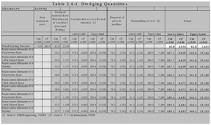
underneath the cast-in-place-concrete structures), cutting of the existing structure, pile driving, dismantling, concrete batch plant operations, utility relocation, and temporary detour structures. Explosives may be required to remove existing bridge piers. Maintaining access for current activities and construction workers and equipment may require temporary reconfiguration of existing roadways, particularly if construction activities require closure of Macalla Road underneath the existing and replacement structures.
Equipment, materials, and work crews may be delivered to the island via barges and other transport vehicles, requiring construction of vessel mooring facilities on the island.
Construction activities for replacement alternatives in the Oakland Touchdown area primarily would be paving, traffic maintenance, excavation of buried rubble and riprap, demolition of some existing roadways and structures, and construction of temporary access trestles, earthen fill, or through dredging in shallow water to provide barge access to the shoreline of the western edge of the Oakland Touchdown area. Bridge structures near the Oakland Touchdown area shoreline would be constructed by pile driving and placement of footings potentially requiring the use of pile-driving equipment from land, trestle, or barge access as described above. Roadways leading onto the structures at the Touchdown could encroach into existing mudflats or Bay waters (northern alignments). These approach structures, which may be partially on the Touchdown and partially encroaching into mudflat areas, would be constructed on concrete slabs supported by piles or imported fill. Excavation of the area could occur to remove riprap or buried fill prior to pile construction. A riprap shoreline would be constructed along the edge of the alignment near the existing shoreline where the bridge elevation is approximately 5 meters (16 feet) above MSL.
Land adjacent to the Caltrans right-of-way on the south side of the existing roadway would likely be required for temporary construction easements. While the amount of area cannot be determined until construction methods are determined, it is likely the construction yard would occupy 1-4 hectares (2.5-10 acres).
Most in-water construction would take place from barges. Special barges and lifting equipment to accommodate heavy equipment needed to support large-scale pile driving and other equipment needed for large bridge construction would be used. Substructure (below bridge) activities would consist primarily of cofferdam construction (vibrating in sheet piles), dewatering, placement of piles into stable Bay bottom soils or rock, and pile caps at the surface of the water. Explosives (in and out of water) may be required to create a bench in bedrock to create a seat for the main span tower foundation for cable-supported design variations, or for piers for the skyway main span. Construction of piers adjacent to YBI, including the main span tower for the cable-supported design variations, would require Bay bottom rock removal to secure the tower foundation. Construction would require falsework in the water and in the main navigation channel. Construction of the main span tower and piers would require large-scale construction equipment to drive large-diameter piles. Floating cranes and tower cranes would be required to construct the main tower and lift the superstructure. Pile drivers would be mounted on deep-draft barges. Barge-mounted concrete batch plants may be used to pump concrete up to new structures. A minimum water depth of 3.6 meters (12 feet) would be needed to provide barge access.
It is expected that cofferdams would be constructed and/or cast-in-steel shell piles would be driven as methods to construct piers. Where piles are driven, mud would be removed from the piles and replaced with concrete pumped from barges. Excavated materials would be disposed of at appropriate locations. Dredge quantities for the build alternatives are shown on Table 2.6-1. Approval of the dredging plan would be required by the Dredged Materials Management Office, which represents state and federal agencies responsible for managing dredging activities in the Bay.
Superstructure (above column tops) construction would require lifting superstructure components, such as girders and bridge deck materials, from barges onto the bridge deck. Delivering long-span girders and lifting them into place would require deep-draft barge access. For a portion of the main span, the superstructure would be delivered to the YBI, set on the shore, and lifted with land cranes. Concrete would be pumped to the bridge deck into forms suspended over the water.
As noted above, in shallow water areas adjacent to the Oakland Touchdown area, trestles, earthen fill, or barges may be used to provide construction equipment access. The use of trestle or fill would provide temporary access into the water for construction equipment.
Dredging would be required for portions of each of the replacement alignments to accommodate barge access because portions of these alignments have water depths shallower than a standard draft barge.
2.6.3 Dismantling of the Existing SFOBB East Span
Dismantling the existing SFOBB East Span would be required to provide land connections to the new span for replacement alternatives at YBI and the Oakland Touchdown area. Removal of the entire bridge would be required by the USCG. The Coast Guard Bridge Administration Manual, Commandant Instruction M16590.5A, requires… "that any part of bridges which are replaced (except those parts incorporated into the new bridge) be removed down to the natural bottom of the waterway…" (See USCG letter dated August 12, 1998, in Appendix G.)
The existing bridge, access trestles, and temporary falsework would be removed under the replacement alternatives. There are two significant physical constraints affecting the dismantling task. First is the proximity of the replacement alignments to the existing spans, which would necessitate performing most marine activities from one side. Secondly, the shallow water depths beneath the spans as they approach the Oakland Touchdown area would require developing special barges or dredging along one side and underneath for deeper draft barge access.
There are seven dismantling activities that involve major components of the bridge:
Major dismantling activities are discussed below and shown on Figure 2-15 (Appendix A).
Removal of deck structures could be performed by separating them into pieces or by removing them panel by panel. Steel truss spans over the water near the Oakland shore could be removed in several different ways. One method is to construct temporary supports under the span and disassemble the truss segment by segment. The shallow water and low clearance under the deck near the Oakland Touchdown make the dismantling impossible by conventional barge and crane methods. Other methods to remove the steel trusses near the shoreline include dredging for barge clearance, constructing access embankments, or using special shallow-draft barges or rigging devices for sliding sections onto barges from the bridge deck. Protective measures would be taken to prevent materials or debris from falling into the Bay. Depending on location, materials could be removed by barge or truck to a predetermined disposal site. The temporary detours on YBI (described in Section 2.6.4 below) would be designed for erection and removal with relatively light equipment.
Large structural elements could be lifted from their bases in one piece or piece by piece. Demolition of the concrete foundations at the piers would require reducing the reinforced concrete to pieces that are small enough to be hauled away. This could be done by mechanical means, by a chemical method that causes the concrete to expand and break apart, or by use of explosives. Removal of the piers to below the mud line could be done by an underwater demolition method or by constructing cofferdams at each pier.
The underwater demolition method includes the removal of concrete using chemical methods or explosives placed by divers. Reduced concrete sections would be removed by mechanical means. The cofferdam method includes construction of a cofferdam around the pier, dewatering, and removal of concrete with jackhammers, concrete saws, drills, and corers. Use of cofferdams is assumed for purposes of estimating dredge disposal quantities generated by existing bridge removal (see Table 2.6-1.)
2.6.4 Detour Structures on Yerba Buena Island and Oakland Touchdown Area
Detour structure options are designed to reroute traffic around the existing structure on YBI and the bridge structures at the Oakland Touchdown area. They would be in place for up to two years (including construction and demolition), depending on traffic routing and construction staging requirements.
On YBI, the detour structures would route traffic around the construction area while portions of the existing East Span are demolished and a new transition structure is completed where the existing bridge now stands. The detour structures would allow the replacement structures to be connected to the retrofitted YBI East Viaduct while minimizing impacts to traffic. For all detour options, it is expected that modifications to the YBI East Viaduct would require off-peak bridge and lane closures to accommodate demolition traffic changes and other construction activities, including final tie-in. Closures would be timed to minimize inconvenience to bridge users.
The N-2 and N-6 Replacement Alternatives detour structure options are located entirely on land and range in length from 580 meters (1,902 feet) to 480 meters (1,574 feet). Only one detour configuration is feasible for Alternative S-4 (see Section 2.7.10 for discussion of YBI temporary detour options that were considered and subsequently withdrawn from further consideration. The S-4 Alternative detour structure would range in length from 400 meters (1,312 feet) to 450 meters (1,476 feet). The S-4 Alternative, North-South Detour, would require placing three temporary piers immediately offshore from YBI. The following is a description of the detour structure options. (See Figures 2-16.1, 2-16.2, 2-17.1 , 2-17.2 and 2-18.1 in Appendix A.)
Replacement Alternatives N-2 and N-6 North-North Detour Options
Eastbound and westbound detour structures would be located north of the YBI transition structure and existing East Span. (See Figures 2-16.1 and 2-17.1 in Appendix A.) The detour structures would be side by side in this option. Both eastbound and westbound traffic would be routed to and from the detour structures onto the new bridge.
Replacement Alternatives N-2 and N-6 North-South Detour Options
Under this option, the westbound detour structure would be constructed north of the transition structure and existing East Span. Westbound traffic would be routed from the new westbound bridge structure onto the detour structure to the YBI Tunnel. The eastbound detour structure would be constructed south of the transition structure and existing bridge (see Figures 2-16.2 and 2-17.2 in Appendix A). Eastbound traffic would exit the tunnel on to the eastbound detour structure and connect to the lower deck of the modified existing bridge which would continue to carry eastbound traffic during construction.
Replacement Alternative S-4 North-South Detour Option
The westbound detour structure would be constructed north of the transition structure and existing bridge. Westbound traffic would be routed from the existing East Span to the detour structure, then back to the tunnel. The eastbound structure would be placed south of the transition structure and existing East Span (see Figure 2-18.1 in Appendix A). Eastbound traffic would exit the tunnel, transition to the eastbound detour structure and to the existing lower deck, which would continue to carry eastbound traffic during the remainder of the construction period.
Construction staging at the Oakland Touchdown area has been defined by environmental and construction constraints. All detouring of traffic will be accomplished using earthen fill on existing ground. Temporary construction easements will be required where the detour limits extend beyond the existing rights-of-way.
Temporary detour roadways at the Oakland Touchdown area would be similar for the northern replacement alternatives. Both eastbound and westbound detour roadways would be constructed to the south of their existing alignments, requiring relocation of the existing Caltrans maintenance road and use of existing U.S. Army and Port of Oakland properties. Construction sequencing would begin with the construction of the westbound approach roadway/structure and rerouting westbound traffic from the westbound detour roadway onto the new westbound structure. Following construction of the eastbound approach and structure, eastbound traffic would shift from the temporary detour onto the new structure, and the Caltrans maintenance road would be realigned to its original location.
Under the S-4 Replacement Alternative, traffic would remain on the existing East Span until completion of the new westbound and eastbound structures. Once the Eastbound structure is completed, eastbound traffic would be diverted from the existing bridge to the new eastbound structure and onto a temporary detour roadway on existing U.S. Army and Port of Oakland properties south of the proposed structure. Westbound traffic would remain on the existing structure until construction is completed for the westbound structure and approach. On completion of the westbound bridge approaches, roughly between stations 87 and 89 on Figure S4-4 (Appendix A), westbound traffic would be diverted to the new westbound structure.
2.7 ALTERNATIVES CONSIDERED AND WITHDRAWN
In addition to the alternatives and project features described above, Caltrans considered a range of other project alternatives which were ultimately withdrawn from further consideration for a variety of reasons. These alternatives (shown on Figure 2-19 in Appendix A) and features are described below, along with the reasons for their withdrawal.
Replacement Alternative N-1 is a 3,685-meter (12,087-foot) long replacement alignment located to the north of Alternative N-6. Eastward from the YBI Tunnel, the N-1 Alternative transitions from a double-deck viaduct to two parallel structures. The transition structure, from double-deck to parallel single-deck structures, is positioned over YBI. The alternative meets project design criteria and accommodates a main span cable-stayed, self-anchored suspension, or skyway design option. A pedestrian/bicycle path could be constructed as part of Alternative N-1.
The N-1 alternative was defined, in part, to respond to recommendations from the MTC Bay Bridge Design Task Force Engineering and Design Advisory Panel (EDAP) calling for an alignment that arced northward to maximize San Francisco skyline views for westbound bridge users and panoramic East Bay Hills and Oakland skyline views for eastbound users.
Alternative N-1 was defined as the northernmost alignment capable of providing skyline views while avoiding Bay bottom zones associated with the ancient Temescal Creek bed. This geologic zone contains deep mud layers. However, based on geologic data obtained after setting the N-1 alignment, it was determined that approximately one-half of the N-1 alignment would fall within areas of deep young Bay mud, increasing the complexity, schedule, and cost of constructing the bridge substructure while potentially reducing seismic performance.
Although Alternative N-1 could be designed to maintain a lifeline vehicular connection in the event of an MCE, construction of the alternative would increase construction schedule and cost without providing substantially enhanced panoramic views when compared to other northern alternatives. Alternative N-1 was withdrawn from further consideration, and additional northern alignments were analyzed for their ability to maximize user views while avoiding undesirable Bay bottom geologic zones.
This alternative, along with Replacement Alternatives N-4 and N-5, was defined through further refinements to northern alignments. Alignment studies were directed to meeting operational and safety design standards to the greatest extent possible while placing the tower for the cable-stayed or self-anchored suspension design variations close to YBI, where geologic conditions are most favorable for the tower footing.
Alternative N-3 would place the main span tower approximately 110 meters (360 feet) offshore from YBI where distance to rock is approximately 20 meters (65 feet) with limited overlay of Bay mud. Location of the tower at this site would facilitate construction schedule by reducing the amount of in-Bay excavation required.
Although tower placement would be optimized under Replacement Alternative N-3, the tower location would require the roadway horizontal and vertical alignments to be modified to less than optimum configurations, resulting in restricted site distances which affect driver response and, ultimately, roadway safety. The distance between the east YBI Tunnel portal and the tower would require the westbound alignment to begin a northward curve immediately upon exiting the tunnel, resulting in restricted sight distance for westbound drivers approaching the tunnel portal. Roadway superelevation, the angle of tilt on a horizontal curve, would be limited to one percent. These design conditions would not meet American Association of State Highway and Transportation Officials (AASHTO) current design standards, requiring application for a mandatory design exception. A design exception would also be required because the westbound on-ramp from YBI would have inadequate sight distance. The N-3 alignment would also require using asphalt to build the height of the lanes on the upper deck of the YBI East Viaduct to connect to the new structure. Based on the inability of the N-3 Replacement Alternative to meet operational and safety design standards to the greatest extent possible, it was withdrawn from further consideration.
Replacement Alternative N-4 was identified through refinement of northern alignments. The N-4 alignment would place the main span tower 120 meters (394 feet) from YBI in the navigation channel. The alignment would be south of the N-1 alignment minimizing intrusion into undesirable Bay bottom geologic zones.
The N-4 alignment was a modification of the N-3 alignment which provided for a 180-meter (591-foot) tangent (straight) roadway section at the YBI Tunnel approach on the westbound alignment. This alternative was defined to prevent westbound traffic entering the tunnel portal on a curve. The N-4 alignment would meet the minimum roadway geometric operational and safety design standards. Overlay of the existing YBI East Viaduct upper deck roadway would be required to conform with the new westbound structure.
Although the N-4 Replacement Alternative met minimal operational and safety design standards, geometric requirements would push the main span tower location further into the navigation channel where distance to rock and depth of Bay mud increased significantly compared to Replacement Alternative N-3. The increased depth to the main span tower would increase project cost and lengthen construction schedule. Based on the deep water tower location, the N-4 Alternative was withdrawn from further consideration, and alternative refinement studies were advanced.
Replacement Alternative N-5 represented a continuation of northern alternative refinement studies. The N-5 alignment would place the main span tower 158 meters (518 feet) offshore from YBI. Compared to the alignments for Alternatives N-3 and N-4, the N-5 alignment consisted of a 6,000-meter (19,685-foot) radius curve on the westbound alignment. As with Alternative N-3, the westbound alignment would enter the YBI Tunnel portal on a curve, although the large curve radius would reduce or eliminate sight distance concerns associated with Alternative N-3. The N-5 alignment would increase the rate of superelevation to two percent, which meets minimum design standards. Pavement build-up of the existing YBI East Viaduct would be required to conform to the new westbound structure.
Based on the desire to place a tangent roadway section at the westbound alignment approach to the YBI Tunnel portal and the need to place and maintain the main span tower as close to YBI as possible, Alternative N-5 was withdrawn from consideration in favor of Alternative N-6.
The S-1 Replacement Alternative was defined as the most direct alignment between YBI and the Oakland Touchdown. As such, it would enter and exit the YBI East Viaduct similar to the existing alignment, eliminating the alignment curves that would provide panoramic vistas of the East Bay hills and the San Francisco skyline.
The S-1 alternative would not meet superelevation design standards for curves at the YBI transition, requiring a mandatory design exception and affecting roadway safety. Adequate superelevation on the horizontal roadway curves could not be provided without removal and reconstruction of a portion of the YBI East Viaduct. S-1 and other southern alternatives have been proposed to reduce impacts to concepts for redevelopment planned on YBI following impending closure of Naval Station Treasure Island. Draft land use redevelopment scenarios would be affected by northern replacement alternatives. Southern replacement alternatives would use areas of YBI with more limited redevelopment potential.
The S-1 Alternative would align the replacement structures parallel to the south of the existing East Span approaching the Oakland Touchdown area. This alignment would require removal and replacement of the EBMUD sewer outfall. This 2.44-meter (8-foot) diameter outfall pipe disperses effluent treated at the EBMUD main treatment facility located immediately to the east of the project area. EBMUD engineering staff reviewed the proposed S-1 alignment and expressed concern that the construction of the replacement bridge structures could damage the outfall pipe and the transverse crossing of the outfall could cause long-term damage and increase complexity of maintenance activities. EBMUD staff determined that relocation of the outfall would be required to avoid potential conflicts. The estimated cost to relocate the outfall is in excess of $100 million. Engineering and environmental reviews likely could not be completed in time to relocate the outfall prior to start of East Span Project construction in 2000.
In response to consultation with EBMUD, Alternative S-1 was revisited. By reducing the horizontal curve radius of the structures adjacent to YBI, the S-1 alignment was modified to more closely parallel the existing East Span at the approach to the Oakland Touchdown area. The modified S-1 alignment would eliminate a transverse, in-Bay crossing of the EBMUD outfall structure by setting the alignment between the existing East Span and the outfall pipe. Although no direct conflict with the outfall structure would occur, concerns remained for construction period effects to the outfall. Further investigation revealed that proposed replacement bridge construction methods requiring dredging to allow barge access to the modified S-1 alignment could not be accommodated within the area between the existing bridge and outfall structure.
Based on the potential conflicts with the EBMUD sewer outfall, the S-1 and modified S-1 alternatives were withdrawn from consideration in favor of southern alignments that minimize or avoid potential conflict with the outfall structure.
Replacement Alternative S-2 represents a continuation of southern alignment studies. The S-2 Replacement Alternative provided broader radius curves at the YBI transition areas, avoiding the need for design exceptions. In response to geometric constraints, the distance to rock suitable for tower footings would also be in excess of 61 meters (200 feet).
The Replacement Alternative S-2 would require construction of detour structures similar to those described for S-3. This raised concerns for structural integrity of the existing East Span cantilever span.
The Replacement Alternative S-2 would avoid an in-Bay transverse crossing of the EBMUD sewer outfall.
Although the Replacement Alternative S-2 would meet mandatory design standards at YBI and would avoid impacts to the EBMUD sewer outfall, it was withdrawn from further consideration due to concerns for structural integrity of the existing cantilever section raised by connection of temporary detour structures.
Replacement Alternative S-3 represents a southern alignment design refinement to better address operational and safety geometric design standards in the YBI transition area. Replacement Alternative S-3 was set at the YBI approach to eliminate the need for design exceptions for superelevation of roadway curves. However, meeting geometric standards would move the main span tower away from YBI to a location where distance to rock suitable for tower footings would be in excess of 61 meters (200 feet). Similar to Replacement Alternative S-1, Replacement Alternative S-3 would not provide bridge users with panoramic views.
Construction staging to maintain five lanes of traffic in each direction would require construction of temporary detour structures out to the cantilever section of the existing East Span. Further investigation indicated that tie-in of the temporary detour structures to the cantilever section would be complex and potentially could compromise structural integrity of the existing structure.
Replacement Alternative S-3 would have impacts to the EBMUD outfall structure similar to those described for Replacement Alternative S-1.
Based on inability to meet mandatory design standards for superelevation, constructibility issues for tie-in of detour structures to the existing East Span, and impacts to the EBMUD sewer outfall, the S-3 Replacement Alternative was withdrawn from further consideration.
2.7.8 Double-deck Alternative
A double-deck replacement bridge was considered early in the evaluation of replacement alternatives. The double-deck alternative could be constructed on north or south alignments. It would provide five vehicular traffic lanes in each direction and inside and outside shoulders.
Preliminary cost estimates, prepared by Caltrans in 1996, indicated the double-deck replacement alternative would be more expensive than the single-deck alternatives.
A double-deck structure would limit views for lower-level bridge users. Lower deck views would be restricted by the upper deck roadway and supports.
Concerns for seismic reliability of double-deck structures have been raised because of extensive damage suffered by existing double-decked structures in recent seismic events, particularly Loma Prieta earthquake damage to the I-880/Cypress Freeway Viaduct in Oakland and the I-480 Embarcadero Freeway in San Francisco. It was determined that a seismically reliable double-deck replacement alternative could be designed using a concept of constructing two linked structures. The upper deck would be supported by a structure straddling an independent lower deck structure. The resulting bridge substructure would be similar in mass to piers and footings for parallel structures.
Based on the inability of the double-deck structure to provide panoramic views, continuing concern that a double-deck structural system is not likely to equal single-deck structures in seismic reliability and no decrease in the amount of in-bay fill resulting from construction of a single structure compared to two parallel bridges, the double-deck replacement alternative was withdrawn from further consideration.
2.7.9 Design Variations Considered
Profile
Replacement alignment refinement studies evaluated options for the bridge profile, which is the rise in roadway elevation from the Oakland Touchdown area to the YBI East Viaduct connection. Three profile variations—level approach grade, constant grade, and elevated grade—were evaluated.
Level Approach Grade profile refers to a vertical alignment that would remain level and near the water surface from the Oakland Touchdown area and begin elevation rise as far west as possible to provide required navigation clearance of 41 meters (135 feet) and conform to the existing YBI East Viaduct. A main span cable-supported design variation would be on such a grade.
Constant Grade indicates a vertical alignment rising at a consistent grade from the Oakland Touchdown area to meet navigation channel clearance requirements and conform at YBI. A main span cable-supported design variation would be on a constant grade.
Elevated Grade modifies the constant grade design variation rise at a slightly elevated grade between the Oakland Touchdown area and the main span. A main span cable-supported design variation would be on a flat slope.
Traffic operational characteristics of each profile variation were evaluated with emphasis on the effect of roadway grade on truck speeds climbing the westbound grade. The analysis concluded that the range of a truck climbing speed difference among the three design variations was approximately six seconds and was not a substantial differentiation among the options.
Because no operational benefits would result from any of the profile design variations, it was not necessary to carry profile design variations to further levels of design refinement. The aesthetic impacts of profile variations were evaluated because profile defines the line that the structures will draw across the horizon. Minor differences in the three design variations would be perceived from most views. At EDAP public meetings, a general preference was stated for the Elevated Grade profile design variation, because cable-supported main span design variations would have a symmetrical appearance from distant views and would contribute to bridge users’ experience of passing through a portal.
There was no support for the Level Approach Grade because it would have the appearance of the San Mateo Bridge, which, although functional and cost-effective, is considered to be inappropriate for the character sought for the East Span replacement structure and withdrawn from further consideration. Caltrans performed a value analysis that resulted in identified significant cost savings by lowering the profile at the main span tower to a position that was similar to the Constant Grade variation and acceptable to the overall bridge architecture. Additionally, with the inclusion of a pedestrian/bicycle path constructed at the same grade as the bridge, the Constant Grade rather than the Elevated Grade would produce slightly slower downhill speeds for bicyclists and result in improved safety. The elevated profile was considered but withdrawn for structural, economic, and marginally improved pedestrian/bicycle reasons. Opportunity to review the profile in this document and make further comments as appropriate will continue through the design process.
Main Span Tower Design Variations
Cable-supported main span design variations were refined under the guidance of the EDAP. Progress designs up to the 30 percent design level for a representative replacement alignment (Replacement Alternative N-6) were developed by project team structural engineers and architects. Extensive public participation and feedback were sought as part of the EDAP review of cable-supported design variations.
Designs for main span towers presented to the EDAP included a single tower between the parallel structures and dual portal towers with interconnected parallel towers arching over each structure. Single- and dual-tower design variations were created for both the cable-stayed and self-anchored suspension design variations.
Single- and dual-tower configurations would meet seismic design criteria to provide a lifeline vehicular connection on the East Span alignment. Dual-tower configurations would require more piers and larger pile caps and footings compared to single-tower designs, increasing the amount of fill in U.S. waters and volume of Bay mud to be excavated during construction.
Following evaluation of seismic safety and aesthetic considerations, the EDAP recommended that main span design variations be designed with a single supporting tower. Based on the EDAP recommendation developed with extensive public comment during public meetings held in the spring and summer of 1998, the increased impacts to U.S. waters required to construct dual towers, and the ability for all replacement alternatives to accommodate the single-tower main span design variations, the dual-tower design variation was withdrawn from further consideration.
Pedestrian/Bicycle Design Variations
Consideration of pedestrian/bicycle access options on East Span Project replacement alternatives has been accomplished through a cooperative process among Caltrans, MTC, members of the Bay Bridge Bicycle/Pedestrian Advisory Committee (BPAC), and the MTC Elderly/Disabled Advisory Committee (EDAC). Alternative configurations for a path on the East Span replacement alternatives were considered in a series of workshops hosted by Caltrans in Fall 1997 and early 1998. The outcome of the workshops, and participation by the BPAC and the EDAC in the MTC Task Force public meetings, was the development of recommendations for either:
For evaluation purposes, Caltrans also continued evaluation of replacement alternatives with no pedestrian/bicycle path.
The BPAC presented its final recommendation to MTC that the single path on the south side of the eastbound structure be included in replacement bridge designs. Based on the expressed preference of BPAC and the MTC Task Force recommendation that toll surcharge funds be used for inclusion of a pedestrian/bicycle path on the replacement structures, the dual path and no path design variations were withdrawn from further consideration and the replacement alternatives description was modified to include the single, south side path.
2.7.10 Detour Structures on Yerba Buena Island Considered and Withdrawn
Optional configurations and locations of YBI temporary detour structures were evaluated in an effort to avoid or minimize impacts to U.S. Coast Guard and U.S. Navy facilities. Possible detour structure alignment configurations were to locate:
Each of these configurations was analyzed for construction feasibility, impacts to YBI resources, and traffic operational impacts. Based on analysis of conceptual engineering designs for the detour options, the detour options described below were withdrawn from further consideration.
Replacement Alternatives N-2 and N-6 South-only Detour Options
The south-only detour structure would be a double-deck structure located south of the existing transition structure. Westbound traffic would travel on the upper deck of the existing bridge to the upper deck of the detour structure, then to the YBI Tunnel. Eastbound traffic would exit the tunnel onto the lower deck of the detour structure, then onto the lower deck of the existing bridge.
The south-only detour option would minimize temporary ground disturbance to U.S. Navy property on YBI, although temporary impacts to the USCG station would increase. Construction of the south-only detour options would require that an 88 meter (288-foot) section of the existing bridge be cut away and removed and replaced with a detour structure. The replacement section would be constructed on YBI then lifted in place. This replacement operation would require complete closure over a 24-hour period of the existing East Span. The total number of sequential days of bridge closure is not known, but is estimated to be in excess of one week. Because of the magnitude of the task to detach and remove the section of the existing bridge, potential for the construction period to be extended would be great.
Based on the complexity of construction and the requirement for complete closure of the entire East Span over a number of days or weeks, the south only alignment detour options were withdrawn from further consideration.
Replacement Alternative S-4 North-only Detour Option
The north-only detour option for Replacement Alternative S-4 would be a double-deck structure constructed north of the existing transition structure and existing East Span. Westbound traffic would travel on the upper deck of the existing bridge to the upper deck of the detour structure then to the tunnel. Eastbound traffic would exit the tunnel onto the lower deck of the detour structure, then onto the lower deck of the existing bridge.
The north-only detour option would be constructed as described for the south-only detour option. It was withdrawn from further consideration for the constructability and traffic operations reasons discussed for the south-only detours.
Replacement Alternative S-4 South-only Detour Option
A south-only detour structure on the S-4 alignment would be two parallel structures. Westbound traffic would be detoured from the existing bridge to the new structure and back to the tunnel. The eastbound structure would be placed south of the transition structure and existing East Span.
A south-south detour option was identified for its potential to avoid temporary disturbance to U.S. Navy properties. However, it would have placed temporary structures over residential structures at the USCG station. More detailed investigation indicated that the south-south detour option would affect construction staging for the S-4 Replacement Alternative. Construction of the westbound detour would conflict with placement of columns for the replacement structure and construction of the eastbound deck of the replacement structure. Based on the construction phasing conflicts, the south-south detour option was withdrawn from further consideration.
Replacement Alternative S-4 North-only Detour Option
The north-only detour option for Replacement Alternative S-4 would be a double-deck structure constructed north of the existing transition structure and existing East Span (see Figure 2-18.1 Appendix A). Westbound traffic would travel on the upper deck of the existing bridge to the upper deck of the detour structure then to the tunnel. Eastbound traffic would exit the tunnel onto the lower deck of the detour structure, then onto the lower deck of the existing bridge.
[end of DEIS 04]